IMAGES TAKEN NEAR TO
Durham Road, STANLEY, DH9 6QQ
Introduction
This page details the photographs taken nearby to Durham Road, DH9 6QQ by members of the Geograph project.
The Geograph project started in 2005 with the aim of publishing, organising and preserving representative images for every square kilometre of Great Britain, Ireland and the Isle of Man.

There are currently over 7.5m images from over14,400 individuals and you can help contribute to the project by visiting https://www.geograph.org.uk
Image Map
Images are licensed for reuse under creativecommons.org/licenses/by-sa/2.0
Notes
- Clicking on the map will re-center to the selected point.
- The higher the marker number, the further away the image location is from the centre of the postcode.
Image Listing (15 Images Found)
Images are licensed for reuse under creativecommons.org/licenses/by-sa/2.0
Image
Details
Distance
1
View up Engels Terrace, South Stanley
Terraced bungalows built up the steep slope of the hillside below Stanley town Centre. The houses were built by Stanley Town Council sometime between the 1930-40's I think. As the name indicates, it was a staunchly Labour authority.
Image: © Robert Graham
Taken: 16 Sep 2019
0.01 miles
2
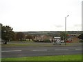
View south from Humber Hill road
The position of Humber Hill, East Stanley, running along the hillside, gives extensive views to the south. Here, looking over to Craghead village and beyond.
Image: © Robert Graham
Taken: 13 Sep 2019
0.08 miles
3
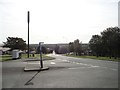
Approaching the road junction at the end of Humber Hill
This is the west end of Humber Hill. There is a major road junction here at the top end of South Stanley, with Durham Road going off to the left and Wear Road coming in from the right down the hill.
Image: © Robert Graham
Taken: 13 Sep 2019
0.09 miles
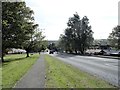
4
Looking down Durham Road from Wear Road
Wear Road continues on as Durham Road at this junction in South Stanley. This suburb is built on the top slopes of the hill south from Stanley town centre and gives wide views over the countryside to the south. The road to the left is Humber Hill.
Image: © Robert Graham
Taken: 13 Sep 2019
0.10 miles
5
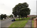
Looking west along Humber Hill road
This road in East Stanley joins Durham Road further on. The position here, on the side of the hill on which Stanley is built, gives good views of the surrounding countryside. The village of Quaking Houses can be made out in the distance.
Image: © Robert Graham
Taken: 13 Sep 2019
0.11 miles
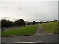
6
Housing estate at Humber Hill
One of several large estates built at South Stanley. Built part way up the slope below Stanley town centre, there are extensive views south and east across Co Durham.
Image: © Robert Graham
Taken: 13 Sep 2019
0.13 miles
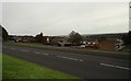
7
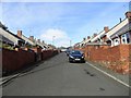
Looking down the length of Durham Road, South Stanley
The suburb of South Stanley occupies the hillside below the town centre. The first council houses were built here in the 1930's I believe, and further estates were built in the 40's and early 50's. More were added in the later 20th century.
Image: © Robert Graham
Taken: 16 Sep 2019
0.17 miles
8
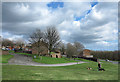
Grassed area with social housing in Stanley
The social housing of Brooks Close and Blakes Close would once have been known as council housing.
Image: © Trevor Littlewood
Taken: 10 Apr 2014
0.17 miles
9
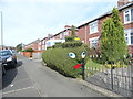
Thomas the Tank Hedge
An amusing piece of topiary on Wear Road, in South Stanley.
Image: © Robert Graham
Taken: 13 Sep 2019
0.20 miles
10
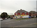
Corner shop on Wear Road, South Stanley
This local convenience store seems to be the equivalent of the old corner shop. On the corner with Tees Crescent.
Image: © Robert Graham
Taken: 13 Sep 2019
0.20 miles