IMAGES TAKEN NEAR TO
DH9 0YP
Introduction
This page details the photographs taken nearby to DH9 0YP by members of the Geograph project.
The Geograph project started in 2005 with the aim of publishing, organising and preserving representative images for every square kilometre of Great Britain, Ireland and the Isle of Man.

There are currently over 7.5m images from over14,400 individuals and you can help contribute to the project by visiting https://www.geograph.org.uk
Image Map
Images are licensed for reuse under creativecommons.org/licenses/by-sa/2.0
Notes
- Clicking on the map will re-center to the selected point.
- The higher the marker number, the further away the image location is from the centre of the postcode.
Image Listing (16 Images Found)
Images are licensed for reuse under creativecommons.org/licenses/by-sa/2.0
Image
Details
Distance
1
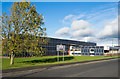
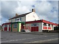
Factory unit, Leadgate Industrial Estate
The buildings immediately in view are those of 'Romag'; it has a further property on an adjacent site further along the road.
The unusual cladding of the building looks remarkably as if solar panels have been used to cover the whole structure - but surely not on that scale! And yet investigation led to finding that Romag is in the solar panel business! Perhaps the panels are just facsimiles?
Image: © Trevor Littlewood
Taken: 24 Oct 2015
0.05 miles
2
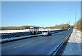
Bus stop in the snow
Bus stop at Leadgate Industrial Estate on the A691.
Image: © Robert Graham
Taken: 13 Dec 2022
0.06 miles
3
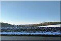
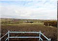
View west from the A691
Looking across a wintry scene from the road south of Leadgate village. The dry stone wall along here is fairly recent, following restoration of an old colliery site.
Image: © Robert Graham
Taken: 13 Dec 2022
0.09 miles
4
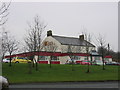
Pavilion Cantonese Restaurant
The Pavilion Cantonese restaurant show from the main road between Durham and Consett.
Image: © Colin Edgar
Taken: 8 Jan 2006
0.15 miles
5
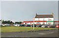
Pavilion Cantonese Restaurant
Between Consett and Durham on the A691.
Image: © Pauline E
Taken: 24 Jul 2009
0.19 miles
6
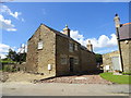
Converted farm building, Iveston
This C19 former byer beside Board Cottage at the west end of Iveston, is being converted to a residential property.
Image: © Robert Graham
Taken: 11 Jun 2014
0.19 miles
7
The Pavilion Cantonese Restaurant
A former pub alongside the A691.
Image: © Christine Johnstone
Taken: 14 Apr 2012
0.19 miles
8
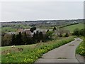
View northwest near Iveston
View from the top of the old road down to Stockerley Bridge. Looking over to Crookhall and Leadgate, with Woody Close Farm in the middle distance.
Image: © Robert Graham
Taken: 19 Feb 2014
0.20 miles
9
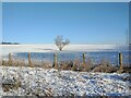
Lone tree in the snow
Tree in the middle of a snowy field beside the A691, south of Leadgate village.
Image: © Robert Graham
Taken: 13 Dec 2022
0.20 miles
10
Woody Close Farm
This farm is tucked into the hillside above the Stockerley Burn, near Iveston. It has been here since the C19, and the farmhouse is probably the original one. The rest of the buildings are C20. Viewed looking west towards Delves Lane and Crookhall, which can be seen in the distance.
Image: © Robert Graham
Taken: 5 May 2014
0.21 miles