IMAGES TAKEN NEAR TO
Ramshaw, CONSETT, DH8 9XA
Introduction
This page details the photographs taken nearby to Ramshaw, DH8 9XA by members of the Geograph project.
The Geograph project started in 2005 with the aim of publishing, organising and preserving representative images for every square kilometre of Great Britain, Ireland and the Isle of Man.

There are currently over 7.5m images from over14,400 individuals and you can help contribute to the project by visiting https://www.geograph.org.uk
Image Map (Loading...)


Getting Data...Please wait
Leaflet Map data © OpenStreetMap
Images are licensed for reuse under creativecommons.org/licenses/by-sa/2.0
Notes
- Clicking on the map will re-center to the selected point.
- The higher the marker number, the further away the image location is from the centre of the postcode.
Image Listing (32 Images Found)
Images are licensed for reuse under creativecommons.org/licenses/by-sa/2.0
Image
Details
Distance
1
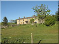
Commerce Hall, now known as Jeffries House
Back in the 1800s when Derwent Lead Mines employed hundreds of men and the Boltsburn valley was a busy community of small farms and cottages, Commerce Hall was the shop premises for Thomas Pears and then his son William, grocers and drapers. William and his four spinster daughters kept the shop running into the 1930s and 1940s, long after the lead mining population had moved on. There's more about William Pears and the lead mining community of Ramshaw, Hunstanworth, County Durham here: http://www.hunstanworthhistory.org.uk/places/chapel.php
Image: © Elfrieda Waren
Taken: 1 Jun 2011
0.00 miles
2
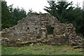
Manor House, Jeffrey's Rake
For many years the home of the Murray family in the mid-1800s, now only a couple of walls remain standing.
Image: © Elfrieda Waren
Taken: 25 Apr 2010
0.06 miles
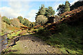
6
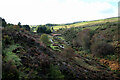
Hard Struggle, Ramshaw
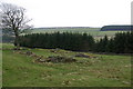
The shrubby wall on the right and the rubble behind it are what remains of Hard Struggle Cottages, shown on an 1850s plan of the valley as three terraced homes. The Wilkinson family lived here around that time. Local legend has it that the properties were called 'Hard Stuggle' because the builder ran out of money and never finished the houses. The local farmer still refers to the track running uphill towards Manor House (another ruin) as Hard Struggle.
Image: © Elfrieda Waren
Taken: 25 Apr 2010
0.10 miles
7
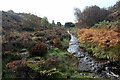
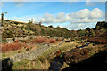
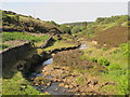
Bolt's Burn upstream of Derwent Lead Mines site
Image: © Andrew Curtis
Taken: 8 Oct 2022
0.11 miles

10
Former Jeffrey's House, Jeffrey's Rake
Today's Jeffrey's House is further down the hill, but on an 1850s plan of the Ramshaw area, this was Jeffrey's House, and the building lower down was 'The Hall of Commerce' inhabited by grocer Thomas Pears and his family.
Image: © Elfrieda Waren
Taken: 25 Apr 2010
0.15 miles