IMAGES TAKEN NEAR TO
Blanchland, CONSETT, DH8 9UX
Introduction
This page details the photographs taken nearby to DH8 9UX by members of the Geograph project.
The Geograph project started in 2005 with the aim of publishing, organising and preserving representative images for every square kilometre of Great Britain, Ireland and the Isle of Man.

There are currently over 7.5m images from over14,400 individuals and you can help contribute to the project by visiting https://www.geograph.org.uk
Image Map
Images are licensed for reuse under creativecommons.org/licenses/by-sa/2.0
Notes
- Clicking on the map will re-center to the selected point.
- The higher the marker number, the further away the image location is from the centre of the postcode.
Image Listing (26 Images Found)
Images are licensed for reuse under creativecommons.org/licenses/by-sa/2.0
Image
Details
Distance
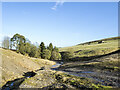
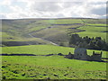
1
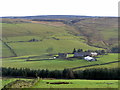
Boltshope from north-west
The chimney of the disused Sikehead Lead Mine can be seen on the hill above the farm Image
To its right the former railway incline can be seen ascending the hill Image
Image: © Andrew Curtis
Taken: 16 Nov 2014
0.04 miles
3
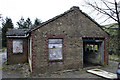
Abandoned offices
Abandoned mine office at Whiteheaps fluorspar mine near Blanchland.
Image: © Helen Wilkinson
Taken: 10 Mar 2007
0.14 miles
4
Old building at Whiteheaps fluorspar mine (disused)
Image: © Mike Quinn
Taken: 14 Sep 2011
0.14 miles
5
Road passing site of Whiteheaps Mine
Whiteheaps Mine closed in 1987. Virtually all evidence of it has been obliterated, just landscaped mine waste can be seen in the image.
Image: © Trevor Littlewood
Taken: 6 Jan 2023
0.15 miles
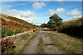
6
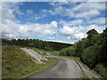
Whiteheaps Mine road
This tarmacked road once served the Whiteheaps Mine which was worked for various minerals over its lifetime, not closing finally until 1987; the mine site itself has virtually been cleared. Evidence of older processing at the site is the pale bank at the left side of the image - crushed material that was discarded once the desired mineral had been extracted.
Image: © Trevor Littlewood
Taken: 16 Jun 2013
0.15 miles
7
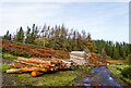
Timber stack at Ramshaw
Old and recently cut logs alongside a road at Ramshaw which led to the Whiteheaps Mine
Image: © Trevor Littlewood
Taken: 12 Nov 2020
0.16 miles
8
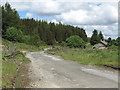
Whiteheaps Mine road
The road is heading towards open moorland so its tarmacked surface might seem unusual but once this road served the Whiteheaps Mine which was worked for various minerals over its lifetime, not closing finally until 1987; the mine site itself has virtually been cleared.
Image: © Trevor Littlewood
Taken: 16 Jun 2013
0.18 miles
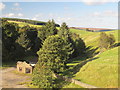
9

The valley of Bolt's Burn below West Farm
Image: © Mike Quinn
Taken: 14 Sep 2011
0.18 miles
10
The valley of Bolt's Burn (2)
Looking down past West Farm and across the valley towards Image
Image: © Mike Quinn
Taken: 14 Sep 2011
0.20 miles