IMAGES TAKEN NEAR TO
Ramshaw, CONSETT, DH8 9UU
Introduction
This page details the photographs taken nearby to Ramshaw, DH8 9UU by members of the Geograph project.
The Geograph project started in 2005 with the aim of publishing, organising and preserving representative images for every square kilometre of Great Britain, Ireland and the Isle of Man.

There are currently over 7.5m images from over14,400 individuals and you can help contribute to the project by visiting https://www.geograph.org.uk
Image Map
Images are licensed for reuse under creativecommons.org/licenses/by-sa/2.0
Notes
- Clicking on the map will re-center to the selected point.
- The higher the marker number, the further away the image location is from the centre of the postcode.
Image Listing (12 Images Found)
Images are licensed for reuse under creativecommons.org/licenses/by-sa/2.0
Image
Details
Distance
2
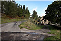
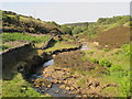
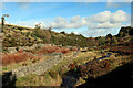
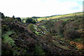
Disturbed ground at Ramshaw
Ramshaw is a dispersed location in the valley of the Bolt's Burn, a tributary of the River Derwent, itself one of the River Tyne. Historically, the valley has been heavily involved in the production of lead, both in the mining of ore and its smelting. There are ruins immediately below the camera location, a small part of them is in view at the foot of the image.
Image: © Trevor Littlewood
Taken: 15 Sep 2021
0.06 miles

4
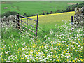
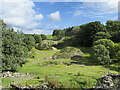
Wildflower meadows
Wildflower hay meadows above the west slope of the valley of Bolt's Burn in County Durham.
Image: © Trevor Littlewood
Taken: 16 Jun 2013
0.14 miles
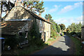
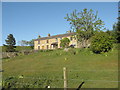
5
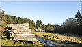
Ramshaw House beyond timber stack
The logs in this stack are aged and must have been there for some years. Certainly they've been there for quite over two years as they're surely some of those seen in this image from November 2020 - https://www.geograph.org.uk/photo/6673447 - although others have been moved.
Image: © Trevor Littlewood
Taken: 6 Jan 2023
0.17 miles
8
Commerce Hall, now known as Jeffries House
Back in the 1800s when Derwent Lead Mines employed hundreds of men and the Boltsburn valley was a busy community of small farms and cottages, Commerce Hall was the shop premises for Thomas Pears and then his son William, grocers and drapers. William and his four spinster daughters kept the shop running into the 1930s and 1940s, long after the lead mining population had moved on. There's more about William Pears and the lead mining community of Ramshaw, Hunstanworth, County Durham here: http://www.hunstanworthhistory.org.uk/places/chapel.php
Image: © Elfrieda Waren
Taken: 1 Jun 2011
0.20 miles