IMAGES TAKEN NEAR TO
CONSETT, DH8 9JY
Introduction
This page details the photographs taken nearby to DH8 9JY by members of the Geograph project.
The Geograph project started in 2005 with the aim of publishing, organising and preserving representative images for every square kilometre of Great Britain, Ireland and the Isle of Man.

There are currently over 7.5m images from over14,400 individuals and you can help contribute to the project by visiting https://www.geograph.org.uk
Image Map
Images are licensed for reuse under creativecommons.org/licenses/by-sa/2.0
Notes
- Clicking on the map will re-center to the selected point.
- The higher the marker number, the further away the image location is from the centre of the postcode.
Image Listing (21 Images Found)
Images are licensed for reuse under creativecommons.org/licenses/by-sa/2.0
Image
Details
Distance
1
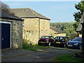
Buildings at Low Waskerley
This former farm has been converted to a range of dwellings in recent years. It was originally a large 19th century planned farmstead. There is a view here between the buildings to the east side of the River Derwent at Shotley Bridge.
Image: © Robert Graham
Taken: 21 Sep 2020
0.01 miles
2
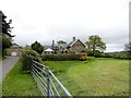
Low Waskerley from the south
This former farming hamlet west of Shotley Bridge is now only residential.
Image: © Robert Graham
Taken: 22 May 2015
0.02 miles
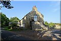
3

Cottage at Low Waskerley
This former farming hamlet is a short distance from Shotley Bridge.
Image: © Robert Graham
Taken: 22 May 2015
0.02 miles
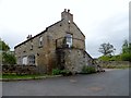
4
Converted farm buildings at Low Waskerley
Low Waskerley is a large planned Victorian farmstead which has been all converted to residential use. This building could have been a byre range with hayloft over, but I wouldn't know for sure.
Image: © Robert Graham
Taken: 21 Sep 2020
0.04 miles
5
Converted farm buildings at Low Waskerley
This settlement to the west of Shotley Bridge was probably an early C19 planned farmstead. All the buildings have now been converted to residential use.
Image: © Robert Graham
Taken: 22 May 2015
0.04 miles
6
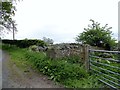
Roadside ruins
These remains of a stone building are beside the lane leading south from Low Waskerley to Shotley Bridge. There is a small building shown here on early Ordnance Survey maps, which could be a cottage or a field barn possibly.
Image: © Robert Graham
Taken: 22 May 2015
0.11 miles
7
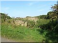
Roadside ruins
Remains of an old building beside the lane south of Low Waskerley. Possibly a 19th century cottage.
Image: © Robert Graham
Taken: 21 Sep 2020
0.11 miles
8
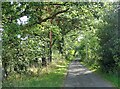
Tree lined lane
Looking south down the country lane which leads past Low Waskerley a bit further on.
Image: © Robert Graham
Taken: 21 Sep 2020
0.13 miles
9
Farm track descending between hedges
The grassed farm track is going downhill towards the River Derwent. The river forms the boundary between two counties - roofs can be seen vaguely between the trees; they are in Shotley Bridge, County Durham whilst the camera position is in Northumberland.
Image: © Trevor Littlewood
Taken: 14 Nov 2015
0.13 miles
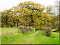
10
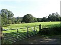
Gateway into grazing field
A field beside the lane south of the former farm at Low Waskerley.
Image: © Robert Graham
Taken: 21 Sep 2020
0.15 miles