IMAGES TAKEN NEAR TO
Rowley, CONSETT, DH8 9HH
Introduction
This page details the photographs taken nearby to DH8 9HH by members of the Geograph project.
The Geograph project started in 2005 with the aim of publishing, organising and preserving representative images for every square kilometre of Great Britain, Ireland and the Isle of Man.

There are currently over 7.5m images from over14,400 individuals and you can help contribute to the project by visiting https://www.geograph.org.uk
Image Map
Images are licensed for reuse under creativecommons.org/licenses/by-sa/2.0
Notes
- Clicking on the map will re-center to the selected point.
- The higher the marker number, the further away the image location is from the centre of the postcode.
Image Listing (28 Images Found)
Images are licensed for reuse under creativecommons.org/licenses/by-sa/2.0
Image
Details
Distance
1
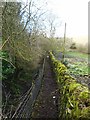
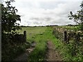
Footpath round Lyar Dene
This narrow footpath makes its way round the boundary of a private garden.
Image: © Oliver Dixon
Taken: 10 Feb 2014
0.02 miles
2
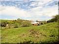
Lyer Dene Farm
This farm is tucked into a steep sided little valley east of the A68 near Rowley.
Image: © Robert Graham
Taken: 26 May 2014
0.07 miles
3
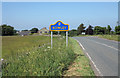
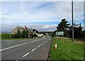
A68 reaching Rowley from the south.
Rowley is a location in County Durham - hardly a village - with just a few houses and a church. There was a railway station here; upon the closure of the line the station was dismantled and rebuilt at the nearby Beamish Open Air Museum; the rail route is now a path and cycle way.
The style of the yellow and blue road sign is typical of many in County Durham.
Image: © Trevor Littlewood
Taken: 11 Jul 2013
0.10 miles
4
Field gateway on Longedge Lane
This country lane runs east from the main A68 south of Castleside. It leads through farming countryside all the way to Lanchester.
Image: © Robert Graham
Taken: 13 Jul 2020
0.10 miles
5
Rowley crossing on the Waskerley Way
At this point, the disused Stanhope and Tyne Railway crosses the A68. The railway http://www.railbrit.co.uk/Stanhope_and_Tyne_Railway/frame.htm was built to serve the needs of the mining industries of north-west County Durham in the 19th century, and the massive ironworks at Consett. This part of the disused line is now known as the Waskerley Way, a component of the C2C cycle route which crosses northern England from coast to coast http://www.sustrans.org.uk/default.asp?sID=1094747349296 http://www.c2c-guide.co.uk/.
In June 2009, floodwaters built up to the west of the embankment (towards camera), broke over the road, demolished the wall and severely damaged the house in the picture.
Image: © Oliver Dixon
Taken: 2 Apr 2010
0.11 miles
6
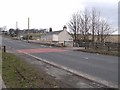
Road junction on the A68
The junction of Healeyfield Lane with the main A68 south of Rowley.
Image: © Robert Graham
Taken: 13 Jul 2020
0.12 miles
7
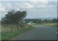
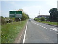
The A68 northbound approaching junctions for Stanhope and Lanchester
Image: © Peter Robinson
Taken: 29 Sep 2013
0.13 miles
8
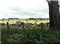
Hay field beside Longedge Lane
Fields south of the lane, looking towards the line of the A68 in the distance.
Image: © Robert Graham
Taken: 13 Jul 2020
0.14 miles
9
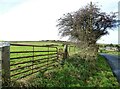
Roadside gate
Beside Healeyfield Lane, at its eastern end. Low Alders farm on the right in the distance. One of the original stone gateposts is still being used here.
Image: © Robert Graham
Taken: 25 Oct 2021
0.14 miles