IMAGES TAKEN NEAR TO
Waskerley, CONSETT, DH8 9DG
Introduction
This page details the photographs taken nearby to DH8 9DG by members of the Geograph project.
The Geograph project started in 2005 with the aim of publishing, organising and preserving representative images for every square kilometre of Great Britain, Ireland and the Isle of Man.

There are currently over 7.5m images from over14,400 individuals and you can help contribute to the project by visiting https://www.geograph.org.uk
Image Map
Images are licensed for reuse under creativecommons.org/licenses/by-sa/2.0
Notes
- Clicking on the map will re-center to the selected point.
- The higher the marker number, the further away the image location is from the centre of the postcode.
Image Listing (4 Images Found)
Images are licensed for reuse under creativecommons.org/licenses/by-sa/2.0
Image
Details
Distance
1
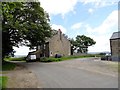
Goldhill farmhouse
Nice old farmhouse on the road between Muggleswick and Waskerley. It looks early 19th century at least and is shown on the 1862 First Series Ordnance Survey map, where it is named as East Goldhill. There was a West Goldhill, which is now only a ruin in the fields opposite the farm.
Image: © Robert Graham
Taken: 18 Jun 2014
0.01 miles
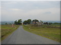
3
Ruins of West Goldhill
The ruins of this former farm lie a short distance west of the present Goldhill Farm, along the track to Carp Shield. The farm name is shown on the 1862 First Series Orddnance Survey map, when it was presumably still inhabited. Interestingly, the present farm is shown as East Goldhill.
Image: © Robert Graham
Taken: 18 Jun 2014
0.10 miles
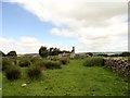
4
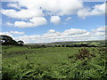
Looking west from Goldhill Lane
This country road runs south from Muggleswick to the Waskerley road, near to the edge of the cultivated countryside. Beyond are the moors of Muggleswick Park and Common, as can be seen here in the distance.
Image: © Robert Graham
Taken: 18 Jun 2014
0.21 miles