IMAGES TAKEN NEAR TO
Waskerley, CONSETT, DH8 9DE
Introduction
This page details the photographs taken nearby to DH8 9DE by members of the Geograph project.
The Geograph project started in 2005 with the aim of publishing, organising and preserving representative images for every square kilometre of Great Britain, Ireland and the Isle of Man.

There are currently over 7.5m images from over14,400 individuals and you can help contribute to the project by visiting https://www.geograph.org.uk
Image Map
Images are licensed for reuse under creativecommons.org/licenses/by-sa/2.0
Notes
- Clicking on the map will re-center to the selected point.
- The higher the marker number, the further away the image location is from the centre of the postcode.
Image Listing (30 Images Found)
Images are licensed for reuse under creativecommons.org/licenses/by-sa/2.0
Image
Details
Distance
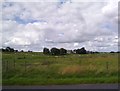
1
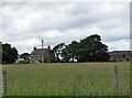
Middle Horsleyhope Farm
One of a string of three farms, High, Middle and Low, set back from the road running up to Waskerley.
Image: © Robert Graham
Taken: 23 Jun 2020
0.01 miles
2
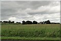
Horsleyhope Farms
A view of Middle and High Horsleyhope Farms from the road to Healeyfield. These farms occupy the last of the grazing fields before the open moorland higher up.
Image: © Robert Graham
Taken: 23 Jun 2020
0.02 miles
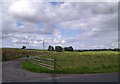
3
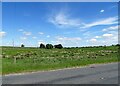
View of Middle Horsleyhope
Looking north from Healeyfield Lane to the middle one of the three Horsleyhope farms.
Image: © Robert Graham
Taken: 4 Jun 2021
0.03 miles
4
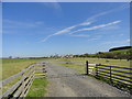
Entrance track to Low Horsleyhope
This once derelict farm has been recently rebuilt.
Image: © Robert Graham
Taken: 8 May 2015
0.05 miles
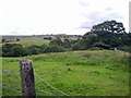
5
Middle Horsleyhope
View across the fields to the farm. There are also High and Low Horsleyhopes nearby.
Image: © Robert Graham
Taken: 15 Aug 2011
0.05 miles
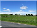
6
Road to Middle Horsleyhope.
Looking along the road to the farm.
Image: © Robert Graham
Taken: 15 Aug 2011
0.06 miles
7
View of High and Middle Horsleyhope Farms from the lane
Two of the three Horsleyhopes, in a line down the road. Although close together, the main part of these farms was the common grazing on the moor to the west for their sheep.
Image: © Robert Graham
Taken: 4 Jun 2021
0.06 miles
8
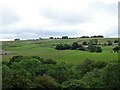
Looking over Horsleyhope
There is a nice view from this spot on Healeyfield Lane, looking west. Horsleyhope woods are in the foreground and the three farms of Low, Middle, and high Horsleyhope are strung across from left to right. Honey Hill Treatment Works is on the top of the bank.
Image: © Robert Graham
Taken: 23 Jun 2020
0.08 miles
9
View northeast from the road
Looking down the road to Castleside. The c attle grid is on the right. Healyfield on the middle horizon.
Image: © Robert Graham
Taken: 15 Aug 2011
0.09 miles
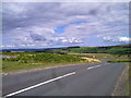
10
View from the road at Cockshot Banks
Looking southwest towards Waskerley. The Moorcock Inn can be seen on the horizon.
Image: © Robert Graham
Taken: 15 Aug 2011
0.12 miles