IMAGES TAKEN NEAR TO
CONSETT, DH8 7TG
Introduction
This page details the photographs taken nearby to DH8 7TG by members of the Geograph project.
The Geograph project started in 2005 with the aim of publishing, organising and preserving representative images for every square kilometre of Great Britain, Ireland and the Isle of Man.

There are currently over 7.5m images from over14,400 individuals and you can help contribute to the project by visiting https://www.geograph.org.uk
Image Map
Images are licensed for reuse under creativecommons.org/licenses/by-sa/2.0
Notes
- Clicking on the map will re-center to the selected point.
- The higher the marker number, the further away the image location is from the centre of the postcode.
Image Listing (11 Images Found)
Images are licensed for reuse under creativecommons.org/licenses/by-sa/2.0
Image
Details
Distance
1
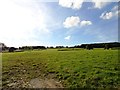
View west from Lund's Lane
Looking over the fields towards the farms of High Woodside, on the right, and Low Woodside, on the left. These are just off the A691 road south of Iveston, near Leadgate.
Image: © Robert Graham
Taken: 7 Oct 2012
0.05 miles
2
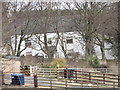
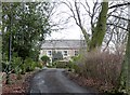
High Woodside farmhouse
Close up view of the farm from the roadside.
Image: © Robert Graham
Taken: 19 Feb 2014
0.09 miles
3
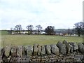
View of High Woodside farm from the main road
The road is the A691 from Leadgate to Durham, via Lanchester. It follows in part the Roman Dere Street. Here, the farm is on the line of the Roman road, but the modern road is a few hundred metres to the west.
Image: © Robert Graham
Taken: 19 Feb 2014
0.11 miles
4
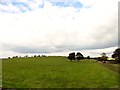
Trees and fields near to High Woodside
Certain of the buildings at High Woodside must be in view but most are concealed among the scattered trees in this view, north-east from the A691 south, of the village of Iveston.
Image: © Trevor Littlewood
Taken: 24 Oct 2015
0.12 miles
5
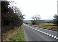
View down the A691 at Woodside
Looking south down the road to Lanchester near High Woodside Farm.
Image: © Robert Graham
Taken: 19 Feb 2014
0.12 miles
6
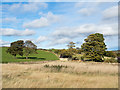
Route of Dere Street at High Woodside
The Roman road ran west from the trees in the field on the right. There is a slight ridge visible across the field which may indicate it's position.
Image: © Robert Graham
Taken: 7 Sep 2014
0.13 miles
7
Low Woodside farmhouse
Low Woodside Farm, west of Lanchester is of ancient origin. It is shown on the first edition Ordnance Survey map of 1862, and is probably older than that. Both this farm, and it's neighbour to the west, High Woodside, lie on the line of Roman Dere Street.
Image: © Robert Graham
Taken: 19 Feb 2014
0.18 miles
8
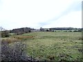
View of Low Woodside from the south
Looking across the fields from the A691 road. This view actually looks up the line of Roman Dere Street, although there is no indication on the ground.
Image: © Robert Graham
Taken: 19 Feb 2014
0.19 miles
9
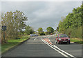
Stockerley Lane junction with Woodside Bank
Stockerley Lane leads to Hurbuck Cottages and Delves - Woodside Bank runs into Leadgate.
Image: © Pauline E
Taken: 10 Oct 2009
0.19 miles
10
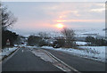
Not long after sunrise, winter solstice
Taken at 08.43
Right turn to Stockerley Lane from Woodside Bank on the first day of winter 2009. For a reverse view, taken a few months earlier, see Image
Image: © Pauline E
Taken: 21 Dec 2009
0.19 miles