IMAGES TAKEN NEAR TO
Iveston, CONSETT, DH8 7SU
Introduction
This page details the photographs taken nearby to DH8 7SU by members of the Geograph project.
The Geograph project started in 2005 with the aim of publishing, organising and preserving representative images for every square kilometre of Great Britain, Ireland and the Isle of Man.

There are currently over 7.5m images from over14,400 individuals and you can help contribute to the project by visiting https://www.geograph.org.uk
Image Map
Images are licensed for reuse under creativecommons.org/licenses/by-sa/2.0
Notes
- Clicking on the map will re-center to the selected point.
- The higher the marker number, the further away the image location is from the centre of the postcode.
Image Listing (15 Images Found)
Images are licensed for reuse under creativecommons.org/licenses/by-sa/2.0
Image
Details
Distance
1
Sunniside Farm
Taken from Lund's Lane
Image: © Graham Scarborough
Taken: 26 Aug 2007
0.01 miles
2
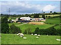
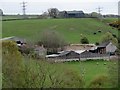
Sunniside Farm near Iveston
This farm dates back to the mid C19 at least, as it's shown on the 1862 Ordnance Survey map. However, it appears to have been entirely rebuilt at some time in the C20. The farmhouse has a 1930's look about it.
Image: © Robert Graham
Taken: 5 May 2014
0.01 miles
3
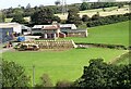
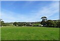
Sunniside farm at Iveston
This farm lies in the fields to the east of the village. It dates back to the mid 19th century at least, but all the present buildings are much younger than that. Second half of the 20th century I would think. There has been a good hay harvest, judging from all the bales.
Image: © Robert Graham
Taken: 14 Sep 2020
0.01 miles
4
Farmhouse at Sunniside farm
This large modern farm lies east of Iveston village. Although the farm is shown on the 1862 Ordnance Survey map, this farmhouse is obviously fairly recent. It could be 1930's from the style. Little seems to remain from the earlier period.
Image: © Robert Graham
Taken: 5 May 2014
0.01 miles
5
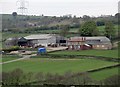
Pit House farm
This little farm lies to the west of Iveston village. It's a bit of a mystery. On older O S maps (up to the 1940's) it is shown as Sunniside Pumping Station. Perhaps connected to mine workings. The sheds here are obviously 20th century, but the house looks older, and could date from the former use. The name Sunniside refers to the nearby large farmstead.
Image: © Robert Graham
Taken: 14 Sep 2020
0.10 miles
6
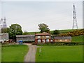
Pit House Farm, Iveston
This farm must be fairly recent, probably mid C20. Prior to this date, there was a pumping station shown on the map here, presumably to pump water from mine workings. It's possible the little farmhouse on the left dates from this earlier period, with the rest of the farm buildings added later.
Image: © Robert Graham
Taken: 5 May 2014
0.11 miles
7
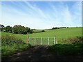
Gate on Stoneyheap Lane
View west from this country lane east of Iveston village.
Image: © Robert Graham
Taken: 14 Sep 2020
0.12 miles
8
View north from Lund's Lane
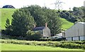
Looking across the countryside to the west of Iveston. In view here are the large farm of Sunniside, and Pontop Pike TV mast on the horizon.
Image: © Robert Graham
Taken: 14 Sep 2020
0.14 miles
9
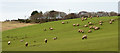
Sheep near to Stony Heap
The field with the grazing animals is on a slope rising north-east from the Iveston Burn.
Image: © Trevor Littlewood
Taken: 23 Jan 2016
0.14 miles
10
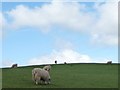
Sheep on a hillside
North of Stonyheap Lane.
Image: © Christine Johnstone
Taken: 14 Apr 2012
0.15 miles