IMAGES TAKEN NEAR TO
Old Station Yard, DURHAM, DH7 9TL
Introduction
This page details the photographs taken nearby to Old Station Yard, DH7 9TL by members of the Geograph project.
The Geograph project started in 2005 with the aim of publishing, organising and preserving representative images for every square kilometre of Great Britain, Ireland and the Isle of Man.

There are currently over 7.5m images from over14,400 individuals and you can help contribute to the project by visiting https://www.geograph.org.uk
Image Map
Images are licensed for reuse under creativecommons.org/licenses/by-sa/2.0
Notes
- Clicking on the map will re-center to the selected point.
- The higher the marker number, the further away the image location is from the centre of the postcode.
Image Listing (7 Images Found)
Images are licensed for reuse under creativecommons.org/licenses/by-sa/2.0
Image
Details
Distance
1
Old station building at Wall Nook
At the east end of Langley Park village. When the station was built for the Lanchester Valley branch line in the 1860's, Langley Park didn't exist in its present form. The station was actually for Witton Gilbert, the next village east along the valley. The stepped gables were a feature of the station houses on this branch.
Image: © Robert Graham
Taken: 10 Jul 2013
0.04 miles
2
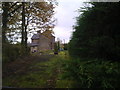
Wall Nook
Little settlement just East of Langley Park.
Image: © Robert Graham
Taken: 2 Nov 2011
0.06 miles
3
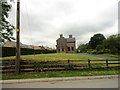
View across to Wallnook from Front Street, Langley Park
Looking across the fields from the road into the village. Waterford Farm is in the centre. The hamlet of Wallnook is a lot older than the main village at Langley Park, which is a late 19th century mining village.
Image: © Robert Graham
Taken: 21 Feb 2022
0.16 miles
4
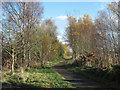
Lanchester Valley Walk
The Lanchester Valley Walk is seen here just east of the old colliery village of Langley Park; the walk follows, as do a number of other routes in County Durham, the course of a dismantled rail route.
Image: © Trevor Littlewood
Taken: 17 Nov 2012
0.18 miles
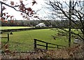
5
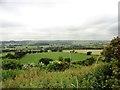
View across the Browney valley
From on top of the escarpment east of Hill Top, Langley Park. The houses in the middle distance are at Kaysburn, the easternmost part of Langley Park.
Image: © Robert Graham
Taken: 10 Jul 2013
0.22 miles
6
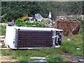
Fly Tipping
North East Waste Services. For All Your Fly Tipping Needs.
Image: © Juliane Savage
Taken: 1 Jan 2016
0.22 miles
7
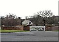
Entrance to Waterford Farm
The entrance gates on Front Street, Langley Park. This is a recent establishment, probably late 20th or 21st century, beside the main road into the village from Durham.
Image: © Robert Graham
Taken: 21 Feb 2022
0.23 miles