IMAGES TAKEN NEAR TO
Fallowfield Terrace, DURHAM, DH6 2SQ
Introduction
This page details the photographs taken nearby to Fallowfield Terrace, DH6 2SQ by members of the Geograph project.
The Geograph project started in 2005 with the aim of publishing, organising and preserving representative images for every square kilometre of Great Britain, Ireland and the Isle of Man.

There are currently over 7.5m images from over14,400 individuals and you can help contribute to the project by visiting https://www.geograph.org.uk
Image Map
Images are licensed for reuse under creativecommons.org/licenses/by-sa/2.0
Notes
- Clicking on the map will re-center to the selected point.
- The higher the marker number, the further away the image location is from the centre of the postcode.
Image Listing (14 Images Found)
Images are licensed for reuse under creativecommons.org/licenses/by-sa/2.0
Image
Details
Distance
2
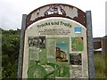
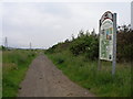
Interpretation board, South Hetton
A survivor, most of these boards have been rendered illegible by idiots with spray cans. This is on an old wagonway, part of the South Hetton Railway or Bradyll's Line which connected South Hetton, Haswell, Shotton and Murton Collieries with Seaham.
Image: © Richard Webb
Taken: 9 Aug 2016
0.08 miles
3
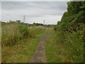
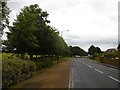
Braddyll's Line
A colliery waggonway, now used as a path.
Image: © Richard Webb
Taken: 9 Aug 2016
0.08 miles
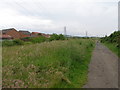
6
Haswell to Hart Countryside Walk
Once a colliery railway track.
Image: © Carol Rose
Taken: 23 Jun 2007
0.14 miles
7
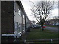
Front Street, South Hetton
The park on the left is the site of South Hetton Colliery which closed in 1982.
Image: © Richard Webb
Taken: 9 Aug 2016
0.15 miles
8
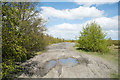
Waste ground crossed by Haswell to Hart Countryside Walkway
The nature of the Haswell to Hart Countryside Walkway passing South Hetton changes from being a pleasant, rural route to one passing through a post-industrial landscape. The grey material here is presumably 'landscaped' colliery waste.
Image: © Trevor Littlewood
Taken: 3 May 2018
0.17 miles
9
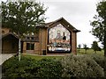
Mural, South Hetton Colliery
Remembering the colliery and its miners. Look up the Durham Mining Museum website for a detailed account of South Hetton and all the other Durham Coalfield mines. Sobering reading.
Image: © Richard Webb
Taken: 9 Aug 2016
0.19 miles
10
Power lines follow the route of the countryside walk
Image: © Carol Rose
Taken: 23 Jun 2007
0.19 miles