IMAGES TAKEN NEAR TO
Poppy Lane, DURHAM, DH6 2LF
Introduction
This page details the photographs taken nearby to Poppy Lane, DH6 2LF by members of the Geograph project.
The Geograph project started in 2005 with the aim of publishing, organising and preserving representative images for every square kilometre of Great Britain, Ireland and the Isle of Man.

There are currently over 7.5m images from over14,400 individuals and you can help contribute to the project by visiting https://www.geograph.org.uk
Image Map
Images are licensed for reuse under creativecommons.org/licenses/by-sa/2.0
Notes
- Clicking on the map will re-center to the selected point.
- The higher the marker number, the further away the image location is from the centre of the postcode.
Image Listing (15 Images Found)
Images are licensed for reuse under creativecommons.org/licenses/by-sa/2.0
Image
Details
Distance
1
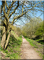
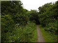
Old railway route north-west of Shotton Colliery
The old rail route is now the Haswell to Hart walkway or cycleway - both terms are used. Additionally, OS maps record the way as the Haswell to Hart Countryside Walkway.
Image: © Trevor Littlewood
Taken: 3 May 2018
0.11 miles
2
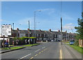
Station Road meeting Salters Lane (B1280) in Shotton Colliery
Image: © Peter Robinson
Taken: 2 Sep 2012
0.12 miles
3

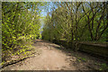
Cycle path following route of former railway
About to leave the last of the housing estates above the cutting at Shotton Colliery on the Hart to Haswell route
Image: © Kevin Waterhouse
Taken: 14 Jun 2023
0.13 miles
4
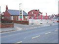
Closed filling station at Shotton Colliery
There seem to be a very large number of filling stations closing up and down the country. Often they finish up as small housing estates. The Fleming public house in the background
Image: © Oliver Dixon
Taken: 10 Apr 2006
0.16 miles
6
Cutting, Shotton Colliery
The Sunderland to Hartlepool Railway ran past Shotton Colliery in a long cutting.
Image: © Richard Webb
Taken: 9 Aug 2016
0.18 miles
7
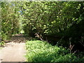
Low walling beside Haswell to Hart route
The Haswell to Hart cycle and walking route now follows the route of the old railway seen here. The low wall has the appearance of a railway platform and there's a ramp, typical of those at the end of platforms at its far end. Also, the location is just north of the road bridge carrying Station Road.
Image: © Trevor Littlewood
Taken: 3 May 2018
0.21 miles
8
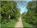
Site of railway station
On the Haswell to Hart Countryside walkway. The old platform is hiding in the bushes to the right
Image: © John Slater
Taken: 27 May 2012
0.22 miles
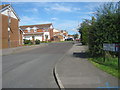
10
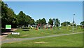
Shotton Recreation Ground
Off Station Road
Image: © Kevin Waterhouse
Taken: 14 Jun 2023
0.23 miles