IMAGES TAKEN NEAR TO
Manor Grove, HOUGHTON LE SPRING, DH4 4NG
Introduction
This page details the photographs taken nearby to Manor Grove, DH4 4NG by members of the Geograph project.
The Geograph project started in 2005 with the aim of publishing, organising and preserving representative images for every square kilometre of Great Britain, Ireland and the Isle of Man.

There are currently over 7.5m images from over14,400 individuals and you can help contribute to the project by visiting https://www.geograph.org.uk
Image Map
Images are licensed for reuse under creativecommons.org/licenses/by-sa/2.0
Notes
- Clicking on the map will re-center to the selected point.
- The higher the marker number, the further away the image location is from the centre of the postcode.
Image Listing (27 Images Found)
Images are licensed for reuse under creativecommons.org/licenses/by-sa/2.0
Image
Details
Distance
2

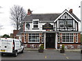
The Stackyard in West Herrington
Village pub and restaurant viewed from the B1286, across St Cuthbert's graveyard. The church itself does not survive. It would have been directly in the line of sight here.
Image: © Robert Graham
Taken: 15 Aug 2023
0.03 miles
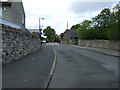
3
St Cuthbet's Road, West Herrington
Although the buildings here are all fairly recent, this was the original village of West Herrington. Much new housing has been built since the last war to the east of here.
Image: © Robert Graham
Taken: 15 Aug 2023
0.03 miles
4
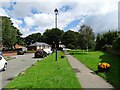
Mclaren Way, West Herrington
The small triangle at the junction on Mclaren Way has been imaginatively planted and landscaped.
Image: © Oliver Dixon
Taken: 15 Nov 2016
0.04 miles
6
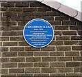
Blue plaque for Len Gibson
This is on the former home of Len Gibson at West Herrington. He was a prisoner of the Japanese during WWII but survived and lived to the age of 101.
Image: © Robert Graham
Taken: 15 Aug 2023
0.05 miles
7
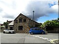
The Stables, West Herrington
This used to be a pub, but it doesn't look as if it is at the moment. It is obviously a converted agricultural building of the 19th century and was presumably part of the establishment of West Herrington Hall which stood nearby. The old village is now gone, replaced by a modern housing estate. This seems to be the only survivor.
Image: © Robert Graham
Taken: 15 Aug 2023
0.06 miles
9
The Stables, West Herrington near Sunderland
The Stables, a cul-de-sac of modern houses, at West Herrington near Sunderland.
Image: © Malc McDonald
Taken: 29 Aug 2011
0.07 miles
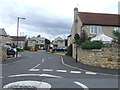
10
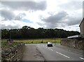
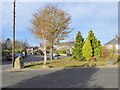
Road junction at West Herrington
The junction of McClaren Way at West Herrington with Herrington Road, the B1286. Herrington Hill rises through the trees on the far side.
Image: © Robert Graham
Taken: 15 Aug 2023
0.08 miles