1
The Stackyard in West Herrington
Village pub and restaurant viewed from the B1286, across St Cuthbert's graveyard. The church itself does not survive. It would have been directly in the line of sight here.
Image: © Robert Graham
Taken: 15 Aug 2023
0.03 miles
2
The Stackyard, West Herrington
Image: © Alex McGregor
Taken: 29 Feb 2012
0.03 miles
3
Path through the graveyard
St Cuthbert's graveyard at West Herrington. The public path runs through the middle of the picture, along the edge of the grassed area.
Image: © Robert Graham
Taken: 15 Aug 2023
0.05 miles
4
St Cuthbet's Road, West Herrington
Although the buildings here are all fairly recent, this was the original village of West Herrington. Much new housing has been built since the last war to the east of here.
Image: © Robert Graham
Taken: 15 Aug 2023
0.05 miles
5
St Cuthbert's graveyard
Beside Herrington Road at West Herrington. This is an old graveyard which stands between the road and the site of the church, which has been demolished.
Image: © Robert Graham
Taken: 15 Aug 2023
0.06 miles
6
Mclaren Way, West Herrington
The small triangle at the junction on Mclaren Way has been imaginatively planted and landscaped.
Image: © Oliver Dixon
Taken: 15 Nov 2016
0.07 miles
7
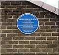
Blue plaque for Len Gibson
This is on the former home of Len Gibson at West Herrington. He was a prisoner of the Japanese during WWII but survived and lived to the age of 101.
Image: © Robert Graham
Taken: 15 Aug 2023
0.07 miles
8
Gateway beside the B1286
On Herrington Road, West Herrington. The stile leads to a footpath up Herrington Hill.
Image: © Robert Graham
Taken: 15 Aug 2023
0.08 miles
9
View east along Herrington Road
The B1286 at West Herrington. This is the east end of the village. The road carries on over the A19 to East Herrington.
Image: © Robert Graham
Taken: 15 Aug 2023
0.08 miles
10
Path sign beside Herrington Road
Footpath sign beside the graveyard of St Cuthbert's Church at West Herrington. Although the graveyard survives, the church no longer does. Herrington Road, the B1286, continues east to East Herrington.
Image: © Robert Graham
Taken: 15 Aug 2023
0.08 miles


