IMAGES TAKEN NEAR TO
Pelaw Bank, CHESTER LE STREET, DH3 3TL
Introduction
This page details the photographs taken nearby to Pelaw Bank, DH3 3TL by members of the Geograph project.
The Geograph project started in 2005 with the aim of publishing, organising and preserving representative images for every square kilometre of Great Britain, Ireland and the Isle of Man.

There are currently over 7.5m images from over14,400 individuals and you can help contribute to the project by visiting https://www.geograph.org.uk
Image Map
Images are licensed for reuse under creativecommons.org/licenses/by-sa/2.0
Notes
- Clicking on the map will re-center to the selected point.
- The higher the marker number, the further away the image location is from the centre of the postcode.
Image Listing (57 Images Found)
Images are licensed for reuse under creativecommons.org/licenses/by-sa/2.0
Image
Details
Distance
1
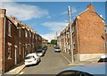
Prospect Street in Chester-le-Street
Image: © Peter Robinson
Taken: 11 Aug 2013
0.11 miles
2
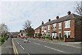
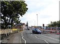
Chester-le-Street: on Newcastle Road
Nearing the centre of the town on an April morning.
Image: © John Sutton
Taken: 22 Apr 2022
0.12 miles
3
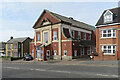
Chester-le-Street Community Centre, Newcastle Road
A nearby information board explains that the centre was opened on 30 November 1929 as South Pelaw Colliery Miners' Welfare Hall. After the pit closed in 1964 "the hall became a community centre very well supported by local residents".
Image: © John Sutton
Taken: 22 Apr 2022
0.13 miles
5
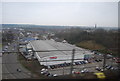
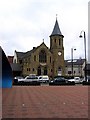
View along North Burns
In Chester le Street town centre. The market place on the right is in the middle of a large scale redevelopment connected with a new culvert for the burn. The spire at the end of the street is on the Methodist Church.
Image: © Robert Graham
Taken: 14 Oct 2019
0.13 miles
6
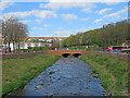
Chester-le-Street: flood alleviation
Chester (or Cong) Burn was culverted under the Market Place in 1962. Following floods in 2012 this was identified as the main cause and a £6.2m scheme funded by Durham County Council, the Environment Agency and the European Union Regional Development Fund which uncovered the burn should reduce the risk of flooding from exceptional storms. A nearby information board explains that the flood walls north and south of the re-exposed burn increase its capacity, allowing it to hold more water to reduce the risk of flooding. The area has been landscaped to "create a more welcoming, park-like feel". The railway viaduct is in the distance to the left of centre.
Image: © John Sutton
Taken: 23 Apr 2022
0.13 miles
7
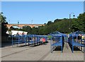
Chester-le-Street: Market Place and viaduct
On a bright September morning.
Image: © John Sutton
Taken: 18 Sep 2013
0.13 miles
10
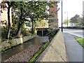
Culvert entrance at Chester le Street
This carries the Chester Burn under the market Place in the town centre at North Burns. There has been a lot of work carried out here recently. The big pier is for the railway viaduct.
Image: © Robert Graham
Taken: 14 Oct 2019
0.14 miles