IMAGES TAKEN NEAR TO
Grange Villa, CHESTER LE STREET, DH2 3LA
Introduction
This page details the photographs taken nearby to DH2 3LA by members of the Geograph project.
The Geograph project started in 2005 with the aim of publishing, organising and preserving representative images for every square kilometre of Great Britain, Ireland and the Isle of Man.

There are currently over 7.5m images from over14,400 individuals and you can help contribute to the project by visiting https://www.geograph.org.uk
Image Map (Loading...)


Getting Data...Please wait
Leaflet Map data © OpenStreetMap
Images are licensed for reuse under creativecommons.org/licenses/by-sa/2.0
Notes
- Clicking on the map will re-center to the selected point.
- The higher the marker number, the further away the image location is from the centre of the postcode.
Image Listing (26 Images Found)
Images are licensed for reuse under creativecommons.org/licenses/by-sa/2.0
Image
Details
Distance
1
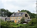
Pelton Grange farm
This farm stands north of Pelton Lane, at the east side of Grange Villa. The farm gave its name to the ex mining village of Grange Villa, which was founded in the late C19 to house miners working at Handen Hold Colliery. The farm is shown on the 1861 First Series Ordnance Survey map. The layout on the map suggests an early Victorian planned courtyard farmstead, but I don't know its exact history. The farmhouse shown here seems to show quite a lot of modernisation.
Image: © Robert Graham
Taken: 12 Aug 2019
0.02 miles
2
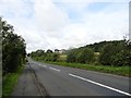
Looking along Pelton Lane
Looking west towards Grange Villa. On the right is Pelton Grange Farm, which gave its name to the C19 mining village.
Image: © Robert Graham
Taken: 12 Aug 2019
0.05 miles
3
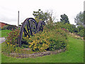
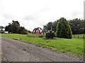
Reminder of the past
Two disused pit head winding wheels have been 'planted' to form a feature among the shrubs in a small public garden in the one-time mining village of Grange Villa.
Image: © Richard Dorrell
Taken: 26 Jul 2011
0.08 miles
4
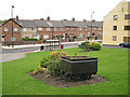
Unusual garden feature
A disused mine truck stands on a short section of rail and is now a feature in a small garden area of the ex-mining village of Grange Villa. The main road in the picture is Pelton Lane. On the right is East Street.
Image: © Richard Dorrell
Taken: 26 Jul 2011
0.08 miles
5
Field close to Grange Villa
A colourful scene: green grass, yellow straw with dung, brown earth and... white stuff! The small village of Grange Villa lies to the right, out of view.
Image: © Trevor Littlewood
Taken: 25 Apr 2016
0.08 miles
6
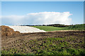
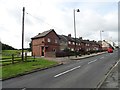
Village entrance at Grange Villa
This is the way into the village from the east, along Pelton lane. The bus from Chester le Street comes in this way also, hence the bus stops.
Image: © Robert Graham
Taken: 12 Aug 2019
0.09 miles
7
Mining memorial at Grange Villa
This stands on the bankside beside Pelton Lane, the main entrance to the village from the east. It commemorates the history of this little ex-mining village. The local pit was West Pelton Colliery, which stood just to the south of the village. The memorial consists of a couple of old winding wheels and a tub, as the little mining cars were called. Many of the local villages have similar installations.
Image: © Robert Graham
Taken: 12 Aug 2019
0.09 miles
8
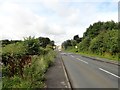
View up Pelton Lane to Grange Villa
This is the route into Grange Villa from the east, coming from Pelton Lane Ends.
Image: © Robert Graham
Taken: 12 Aug 2019
0.09 miles
9
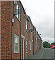
Satellite dishes
I am guessing that satellite is the only way of receiving digital TV in this small rural village. This is East Street, one of several similar terraces in Grange Villa.
Image: © Richard Dorrell
Taken: 26 Jul 2011
0.10 miles
10
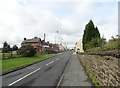
Coronation Terrace, Grange Villa
This street must be named for the coronation of either Edward VII in 1902, or George V in 1911. I suspect it's the latter. The first houses in this old pit village were built in the 4th quarter of the C19, but most of the present village dates from the period between 1900 and the First World War. This view is along the main village street.
Image: © Robert Graham
Taken: 12 Aug 2019
0.11 miles