IMAGES TAKEN NEAR TO
Grange Terrace, CHESTER LE STREET, DH2 2PD
Introduction
This page details the photographs taken nearby to Grange Terrace, DH2 2PD by members of the Geograph project.
The Geograph project started in 2005 with the aim of publishing, organising and preserving representative images for every square kilometre of Great Britain, Ireland and the Isle of Man.

There are currently over 7.5m images from over14,400 individuals and you can help contribute to the project by visiting https://www.geograph.org.uk
Image Map
Images are licensed for reuse under creativecommons.org/licenses/by-sa/2.0
Notes
- Clicking on the map will re-center to the selected point.
- The higher the marker number, the further away the image location is from the centre of the postcode.
Image Listing (19 Images Found)
Images are licensed for reuse under creativecommons.org/licenses/by-sa/2.0
Image
Details
Distance
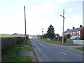
1
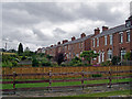
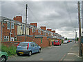
Grange Terrace
On this side of the houses are long gardens leading onto the B6313, Bluehouse Bank. At their backs (fronts?) is a further minor road, across which the houses have further land. The housing would have been built to provide homes for miners working in the many nearby coal mines. Nothing visible now remains here of the former mine workings.
Image: © Richard Dorrell
Taken: 26 Jul 2011
0.00 miles
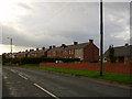
2
Grange Terrace, Pelton Fell
These were built in the late 19th century for miners from the nearby Pelton Fell Colliery. The design is not quite as utilitarian as most pit houses of the time, with curved brick soldier arches above the door and the ground floor windows.
Image: © Robert Graham
Taken: 14 Oct 2019
0.01 miles
3
Pelton Fell: Grange Terrace
Originally colliery cottages, photographed not long after eight o'clock on a bright September morning.
Image: © John Sutton
Taken: 18 Sep 2013
0.02 miles
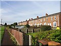
4
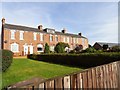
Grange Terrace, Pelton Fell
Colliery cottages on a bright September morning. To the right are the single-storey old people's homes built in 1950 by Chester-le-Street Urban District Council.
Image: © John Sutton
Taken: 18 Sep 2013
0.03 miles
5
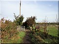
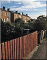
Footpath gate
Across the path leading north from Grange Terrace in Pelton Fell to Newfield.
Image: © Robert Graham
Taken: 14 Oct 2019
0.05 miles
7
Looking down Grange Terrace
A long late 19th century row of formers miners house on Pelton Fell Road. View is looking west. The name was taken from Pelton Grange farm, which stood at the end of the street, but is now gone.
Image: © Robert Graham
Taken: 14 Oct 2019
0.07 miles
10
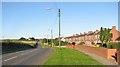
New Grange Terrace
The housing remains, but the works have gone. Nothing visible remains of the coal mine workings which stood within walking distance of these terraced cottages on the outskirts of Chester-le-Street.
Image: © Richard Dorrell
Taken: 26 Jul 2011
0.08 miles