IMAGES TAKEN NEAR TO
Coupland Way, DURHAM, DH1 3SA
Introduction
This page details the photographs taken nearby to Coupland Way, DH1 3SA by members of the Geograph project.
The Geograph project started in 2005 with the aim of publishing, organising and preserving representative images for every square kilometre of Great Britain, Ireland and the Isle of Man.

There are currently over 7.5m images from over14,400 individuals and you can help contribute to the project by visiting https://www.geograph.org.uk
Image Map
Images are licensed for reuse under creativecommons.org/licenses/by-sa/2.0
Notes
- Clicking on the map will re-center to the selected point.
- The higher the marker number, the further away the image location is from the centre of the postcode.
Image Listing (9 Images Found)
Images are licensed for reuse under creativecommons.org/licenses/by-sa/2.0
Image
Details
Distance
1
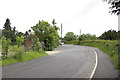
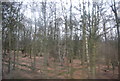
Course of old Durham Road, Stonebridge (2)
Following the building of the A690 in the first half of the twentieth century, the old Durham Road has effectively become a slip road.
Image: © MrC
Taken: 20 Jun 2010
0.02 miles
2
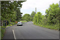
Course of old Durham Road, Stonebridge (1)
Following the building of the A690 in the first half of the twentieth century, the old Durham Road has effectively become a slip road.
Image: © MrC
Taken: 20 Jun 2010
0.06 miles
5
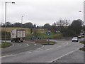
Stonebridge Roundabout on the A690
The main road from Crook and Willington to Durham city. Looking north-east towards Durham. The B6302 from Esh Winning comes in from the left.
Image: © Oliver Dixon
Taken: 17 Feb 2006
0.15 miles
7
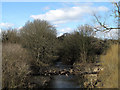
Pipeline over River Browney at Stonebridge
Stonebridge is a location on the outskirts of Durham City where there's a stone bridge and a pub of the same name. This view is from the A690 at a roundabout at Stonebridge, along the River Browney showing a pipeline crossing the river. The accumulated debris at the caging of the pipeline can surely only have been deposited there by the river being in flood; it would have been a remarkable sight!
Image: © Trevor Littlewood
Taken: 19 Sep 2010
0.20 miles
9
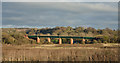
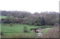
Railway viaduct over River Deerness
The viaduct carries the East Coast Main Line over the River Deerness close to its confluence with the River Browney.
Image: © Trevor Littlewood
Taken: 30 Nov 2014
0.25 miles