IMAGES TAKEN NEAR TO
Carsluith, NEWTON STEWART, DG8 7DX
Introduction
This page details the photographs taken nearby to DG8 7DX by members of the Geograph project.
The Geograph project started in 2005 with the aim of publishing, organising and preserving representative images for every square kilometre of Great Britain, Ireland and the Isle of Man.

There are currently over 7.5m images from over14,400 individuals and you can help contribute to the project by visiting https://www.geograph.org.uk
Image Map
Images are licensed for reuse under creativecommons.org/licenses/by-sa/2.0
Notes
- Clicking on the map will re-center to the selected point.
- The higher the marker number, the further away the image location is from the centre of the postcode.
Image Listing (10 Images Found)
Images are licensed for reuse under creativecommons.org/licenses/by-sa/2.0
Image
Details
Distance
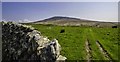
2

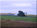
Cambret Farm
Found at the end of a long single track road that rises from Carsluith to this moorland spot west of Cairnharrow Hill which can be seen in the background behind the barn. The farm also sits on the line of a footpath that goes from Claughreid to the Old Military Road across the moors.
Image: © Andy Farrington
Taken: 29 Apr 2014
0.01 miles
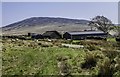
3
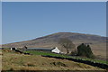
Cambret Farm
Cambret hill farm at the end of the lane/track from Carsluith with Cairnharrow (456m) in background.
Image: © Chris Newman
Taken: 7 Jul 2008
0.01 miles
4
Cambret
A view towards Cairnharrow [NX5356]
Image: © Leslie Barrie
Taken: 19 Apr 2009
0.01 miles
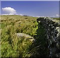
5
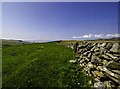
Stane Dyke Wall at Cambret
View from the farm on the moors down to Wigtown Bay and the Machars. Mist on the bay had failed to be burned off since the early morning, when I first noticed the covering before leaving home at Braehead on the other side of the bay.
Image: © Andy Farrington
Taken: 29 Apr 2014
0.05 miles
6
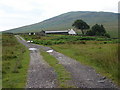
Cambret Farm view to Cairnharrow
Farm tracks take the eyes through the moors and across to the hill at Cairnharrow on the horizon. I was on the top of the hill two years ago at the trig point, which is at the 456 metre mark, and the weather conditions all day on the moors and hills were a combination of misle and rain with poor visibility, making it difficult Geographing the views and vistas. Today, the view was quite different from the farm, with blue skies and few clouds, showing me the importance of returning to places again and again.
Image: © Andy Farrington
Taken: 29 Apr 2014
0.05 miles
7
Footpath to Cambret
Returning to the farm the previously settled sheep at the front of the buildings decide to make a run keeping in mind it is long past lunch time.
Image: © Andy Farrington
Taken: 29 Apr 2014
0.05 miles
8
Cambret
Following the line of the dyke from Cambret Farm will take you across Cambret Moor to Cambret Hill, where you are likely to get a good signal for your mobile phone and a great picture on BBC1 using the local masts in place for that very purpose.
Image: © Andy Farrington
Taken: 29 Apr 2014
0.07 miles
9
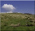
Cambret Moor
View across the moorland to the masts on Cambret Hill a significant point of interest in the area.
Image: © Andy Farrington
Taken: 29 Apr 2014
0.13 miles
10
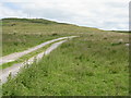
Farm track to Cambret
From the end of the public road.
Image: © M J Richardson
Taken: 3 Jul 2019
0.21 miles