IMAGES TAKEN NEAR TO
Troqueer, DUMFRIES, DG2 8LX
Introduction
This page details the photographs taken nearby to DG2 8LX by members of the Geograph project.
The Geograph project started in 2005 with the aim of publishing, organising and preserving representative images for every square kilometre of Great Britain, Ireland and the Isle of Man.

There are currently over 7.5m images from over14,400 individuals and you can help contribute to the project by visiting https://www.geograph.org.uk
Image Map
Images are licensed for reuse under creativecommons.org/licenses/by-sa/2.0
Notes
- Clicking on the map will re-center to the selected point.
- The higher the marker number, the further away the image location is from the centre of the postcode.
Image Listing (7 Images Found)
Images are licensed for reuse under creativecommons.org/licenses/by-sa/2.0
Image
Details
Distance
1
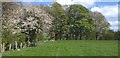
Hawthorn in bloom
Edge of good grazing land before entering Conhuith plantation a mixed native woodland.
Image: © Colin Kinnear
Taken: 27 Apr 2020
0.18 miles
2
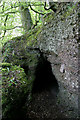
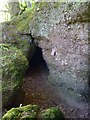
The Covenanters' Cave near Cargenbridge
This small cave is located to the southeast of Cargenbridge in Conhuith Plantation on steep ground overlooking the Cargen Water. The entrance is approximately 800mm wide by 1.4m high and tapers back in width and height for about 2.5m. The cave would be capable of hiding a few men in the time of the Covenanters when Presbyterians were persecuted by government soldiers for their religious beliefs. I had an interesting encounter here with fellow geographer Darrin Antrobus who was photographing the same cave. He is the first geographer I have met by chance since I joined Geograph in July 2006 and although the odds must be high on this encounter, we were both responding to a photographic request by another member. This is Darrin’s shot from his iPhone pic Image
Image: © Walter Baxter
Taken: 8 May 2010
0.23 miles
3
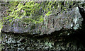
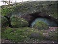
A rock carving at the Covenanters' Cave near Cargenbridge
There are some letters carved into the rock face above the entrance to this cave Image
Image: © Walter Baxter
Taken: 8 May 2010
0.23 miles
4
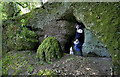
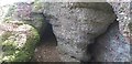
Tess and Darrin at the Covenanters' Cave
There is a small cave to the southeast of Cargenbridge that is marked on the Ordnance Survey Map as Covenanters’ Cave. It is located in a strip wood on steep ground overlooking the Cargen Water and is associated with the Covenanting times when Presbyterians were persecuted by government soldiers for their religious beliefs. The entrance to the cave is on the left Image By pure chance I met up here with fellow geographer Darrin Antrobus accompanied by his dog Tess. He was also taking photos of the cave with his iPhone pic Image
Image: © Walter Baxter
Taken: 8 May 2010
0.23 miles
5
Covenanters' Cave
A little story goes along with this... I'd seen this cave marked on the map, and I've lived in the area for eleven years but I'd never been there... always said to myself that I wanted to take a look but never did... A few weeks ago, I got an email from a woman asking if I had a picture of this Covenanter's Cave near Cargenbridge. Apparently she grew up in the area. I told her I had never been but I'd go take a pic, as I was curious about it anyway.
So I go up there today and quite coincidentally there was another Geographer, Walter Baxter, there doing the same thing, arriving just about the same time... the woman had also contacted him about wanting a picture of this cave.
It was great to meet Walter, a much more accomplished geographer than I, whose picture will no doubt be a bit better than my iPhone pic.
Image: © Darrin Antrobus
Taken: 8 May 2010
0.23 miles
6
Covenanters' Cave
View of cave,to find look for the tall conifer in the trees from east side
Image: © rod collier
Taken: 10 Apr 2010
0.24 miles
7
Covenanters' Cave
A small cave in a conglomerate outcrop.
Image: © Colin Kinnear
Taken: 27 Apr 2020
0.24 miles