IMAGES TAKEN NEAR TO
Inverbervie, MONTROSE, DD10 0SR
Introduction
This page details the photographs taken nearby to DD10 0SR by members of the Geograph project.
The Geograph project started in 2005 with the aim of publishing, organising and preserving representative images for every square kilometre of Great Britain, Ireland and the Isle of Man.

There are currently over 7.5m images from over14,400 individuals and you can help contribute to the project by visiting https://www.geograph.org.uk
Image Map
Images are licensed for reuse under creativecommons.org/licenses/by-sa/2.0
Notes
- Clicking on the map will re-center to the selected point.
- The higher the marker number, the further away the image location is from the centre of the postcode.
Image Listing (48 Images Found)
Images are licensed for reuse under creativecommons.org/licenses/by-sa/2.0
Image
Details
Distance
1
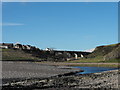
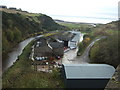
The Jubilee Bridge, Inverbervie
View towards the east end of Inverbervie over the Bervie Water showing the Jubilee Bridge opened in 1935. Conglomerate cliff to right.
Image: © Dona Robbins
Taken: 30 Oct 2010
0.15 miles
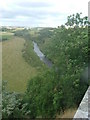
2
Bervie Water
Heading towards the sea. From Bervie Jubilee Bridge.
Image: © JThomas
Taken: 11 Nov 2013
0.15 miles
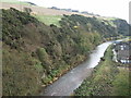
3
The Bervie Burn
Flowing southeast, towards the old bridge then the sea.
Image: © Stanley Howe
Taken: 24 Aug 2005
0.16 miles
4
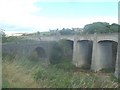
Where two bridges meet
The old and the new at the north end of Inverbervie.
Image: © Stanley Howe
Taken: 24 Aug 2005
0.16 miles
6
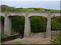
The Jubilee Bridge
Carrying the A92 coast road. Opened on 21.08.1935.
Image: © jamesnicoll
Taken: 26 May 2010
0.17 miles
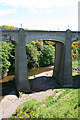
7
From one bridge to another
Standing on the Bervie Bridge looking at the Bervie Jubilee bridge
Image: © Ralph Greig
Taken: 29 May 2021
0.18 miles
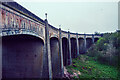
8
Jubilee Bridge
This bridge was opened in 1935, and carries the A92, formerly the trunk road, across the Bervie Water, replacing the older bridge on 1799 from which this view is taken.
Image: © Anne Burgess
Taken: 1 Jun 2013
0.18 miles
9
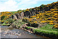
Quarry by the Bervie Water
At least I think it must be a quarry, possibly used for stone to build the Jubilee Bridge, because it doesn't seem to be marked as such on the maps. No doubt someone will correct me if I'm wrong.
Image: © Anne Burgess
Taken: 1 Jun 2013
0.18 miles
10
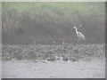
Heron, Bervie Water
View from a tent on a foggy morning.
Image: © Richard Webb
Taken: 3 Aug 2011
0.18 miles