IMAGES TAKEN NEAR TO
Bush, MONTROSE, DD10 0DH
Introduction
This page details the photographs taken nearby to Bush, DD10 0DH by members of the Geograph project.
The Geograph project started in 2005 with the aim of publishing, organising and preserving representative images for every square kilometre of Great Britain, Ireland and the Isle of Man.

There are currently over 7.5m images from over14,400 individuals and you can help contribute to the project by visiting https://www.geograph.org.uk
Image Map
Images are licensed for reuse under creativecommons.org/licenses/by-sa/2.0
Notes
- Clicking on the map will re-center to the selected point.
- The higher the marker number, the further away the image location is from the centre of the postcode.
Image Listing (10 Images Found)
Images are licensed for reuse under creativecommons.org/licenses/by-sa/2.0
Image
Details
Distance
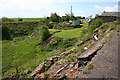
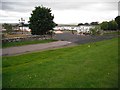
1
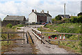
Bourtree Bush
This hamlet is named simply as Bush on the modern maps, and on its signpost, but the mid-Victorian six-inch Ordnance Survey map calls it Bourtree Bush. The three nearest houses are the oldest remaining ones. In the foreground is the former main road, but the bridge over the Den of Lauriston has collapsed on both sides. Even the fenced pedestrian path is now closed off at both ends; the barriers are just this side of the nearest building.
Image: © Anne Burgess
Taken: 1 Jun 2013
0.00 miles
2
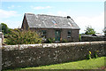
Old Cottage at Bourtreebush
This uninhabited cottage is marked on the mid-Victorian six-inch map, which also names the hamlet as Bourtreebush. Its modern name is plain Bush.
Image: © Anne Burgess
Taken: 1 Jun 2013
0.02 miles
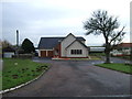
3
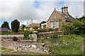
Cottage at Bush
This, and the three houses on the other side of the old main road, are the only buildings left in Bush of those marked on the mid-Victorian six-inch map. All the rest have been replaced by modern houses.
Image: © Anne Burgess
Taken: 1 Jun 2013
0.03 miles
4
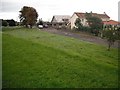
Bush
The old alignment of the A92 which now bypasses the hamlet.
Image: © Richard Webb
Taken: 21 Sep 2009
0.03 miles
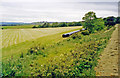
5
Crumbling Roadway
The edge of the old main road at Bush is splitting and slipping downhill. The remains of the parapet can be seen lying on the grass a few feet down the slope. The embankment at the far side of the dip is the former railway line to Inverbervie.
Image: © Anne Burgess
Taken: 1 Jun 2013
0.04 miles
7
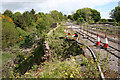
Collapsing Bridge
The north parapet of the former main road bridge across the Den of Lauriston at Bush is in imminent danger of collapsing, just as its fellow on the south side has already done.
Image: © Anne Burgess
Taken: 1 Jun 2013
0.06 miles
8
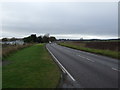
A92 heading south west at Bush
Towards Montrose.
National Cycle Route 1.
Image: © JThomas
Taken: 11 Nov 2013
0.07 miles
10
Site of former Lauriston station
View SW, towards Montrose: ex-NBR Montrose - Inverbervie branch, closed to passengers 1/10/51, but to goods not until 23/5/66.
Image: © Ben Brooksbank
Taken: 29 Jun 2002
0.20 miles