IMAGES TAKEN NEAR TO
Holly Bank, CREWE, CW3 0LF
Introduction
This page details the photographs taken nearby to Holly Bank, CW3 0LF by members of the Geograph project.
The Geograph project started in 2005 with the aim of publishing, organising and preserving representative images for every square kilometre of Great Britain, Ireland and the Isle of Man.

There are currently over 7.5m images from over14,400 individuals and you can help contribute to the project by visiting https://www.geograph.org.uk
Image Map
Images are licensed for reuse under creativecommons.org/licenses/by-sa/2.0
Notes
- Clicking on the map will re-center to the selected point.
- The higher the marker number, the further away the image location is from the centre of the postcode.
Image Listing (39 Images Found)
Images are licensed for reuse under creativecommons.org/licenses/by-sa/2.0
Image
Details
Distance
1
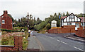
Site of Audlem station, 1990
View eastward on the A529 road, where the ex-GWR (Crewe) - Nantwich (to left) - Market Drayton (to right) - Wellington secondary main line used to cross. The station, which was on the right, was closed to passengers from 9/9/63 (with the Crewe - Wellington passenger service) and to goods from 2/2/64, but the Nantwich - Wellington line - always important for freight, survived until 8/5/67.
Image: © Ben Brooksbank
Taken: 27 Aug 1990
0.03 miles
2
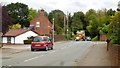
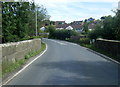
Whitchurch Road, A525
Heading east into Audlem.
Image: © Jonathan Billinger
Taken: 9 Sep 2015
0.03 miles
3
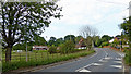
Whitchurch Road south-west of Audlem in Cheshire
This shows the A525 Whitchurch Road, looking north-east towards Audlem.
Image: © Roger Kidd
Taken: 5 Jun 2018
0.03 miles
4
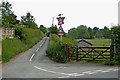
Mill Lane south-west of Audlem in Cheshire
Mill Lane led to the former Swanbach Mill.
Image: © Roger Kidd
Taken: 5 Jun 2018
0.05 miles
6
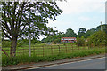
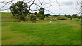
Pasture near Copthorne in Cheshire
Seen from Whitchurch Road, the image shows the flood plain of the River Weaver.
Image: © Roger Kidd
Taken: 5 Jun 2018
0.06 miles
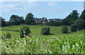
8
Cheshire farmland south-west of Audlem
This telephoto assisted image of pasture is by the River Weaver, near Copthorne.
Image: © Roger Kidd
Taken: 5 Jun 2018
0.07 miles
9
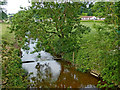
River Weaver from Audlem Bridge in Cheshire
This is the River Weaver, looking north (downstream) from Audlem Bridge on the A525 Whitchurch Road.
Image: © Roger Kidd
Taken: 5 Jun 2018
0.08 miles
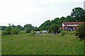
10
The Weaver valley
Looking north across the water meadow from the A525 just to the west of Audlem.
Image: © Jonathan Billinger
Taken: 9 Sep 2015
0.08 miles