IMAGES TAKEN NEAR TO
Jack Mills Way, CW2 5UT
Introduction
This page details the photographs taken nearby to Jack Mills Way, CW2 5UT by members of the Geograph project.
The Geograph project started in 2005 with the aim of publishing, organising and preserving representative images for every square kilometre of Great Britain, Ireland and the Isle of Man.

There are currently over 7.5m images from over14,400 individuals and you can help contribute to the project by visiting https://www.geograph.org.uk
Image Map
Images are licensed for reuse under creativecommons.org/licenses/by-sa/2.0
Notes
- Clicking on the map will re-center to the selected point.
- The higher the marker number, the further away the image location is from the centre of the postcode.
Image Listing (43 Images Found)
Images are licensed for reuse under creativecommons.org/licenses/by-sa/2.0
Image
Details
Distance
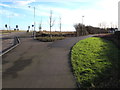
1
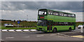
New roundabout, B5071
The B5071 has been rerouted to provide a link between Crewe and the new A500 to the south.
The bus is a Volvo Olympian, owned by local operator Routemaster Buses, on a shuttle service between Crewe Station and Gresty Bridge for the DRS depot open day.
In the background, train-spotters are checking Basford Hall railway sidings.
Current plans show the land over the fence as the site for an HS2 infrastructure maintenance depot.
Image: © Ian Taylor
Taken: 23 Jul 2016
0.02 miles
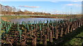
2
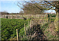
Brook near Greenbank Farm
The public footpath from Gresty Road to Basford crosses a small brook, a tributary of Gresty Brook. Between the fences (centre left) runs a track to Greenbank Farm (not a right of way). In the distance, from left to right, are Greenbank Farm outbuildings, Rail House by Crewe station & warehousing by Basford Hall Sorting Sidings
Image: © Espresso Addict
Taken: 4 Apr 2007
0.06 miles
3
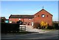
Farm buildings at Yew Tree Farm, near Crewe
Several farms lie around Crewe Road (B5071), immediately to the south of the city of Crewe. These farm buildings on a right-angle bend show the typical features of the area, with circular windows, arched entrances and cross-shaped ventilation holes. The chimneys of the Mornflakes plant, visible across much of the square, can be seen in the distance (left)
Image: © Espresso Addict
Taken: 4 Apr 2007
0.09 miles
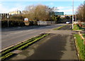
5
Path junction beyond the southern edge of Crewe
The path on the right diverges from the pavement alongside the B5071 Gresty Road.
Image: © Jaggery
Taken: 4 Feb 2017
0.12 miles
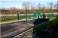
6
Recently planted trees at the edge of a pond, Crewe
Viewed from the B5071 Gresty Road at the southern edge of Crewe in February 2017.
Image: © Jaggery
Taken: 4 Feb 2017
0.14 miles
7
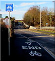
End of cycle route, Gresty Road, Crewe
Alongside the B5071 Gresty Road a few metres from the Welcome to Crewe sign https://www.geograph.org.uk/photo/5954172 at the southern edge of the town.
Image: © Jaggery
Taken: 4 Feb 2017
0.15 miles
8
Electricity substation at the southern edge of Crewe
In a compound set back from the east side of the B5071 Gresty Road.
Image: © Jaggery
Taken: 4 Feb 2017
0.15 miles
9
B5071 at the southern edge of Crewe
The B5071 Gresty Road passes the Welcome to Crewe sign https://www.geograph.org.uk/photo/5954172 on the left.
Image: © Jaggery
Taken: 4 Feb 2017
0.16 miles
10
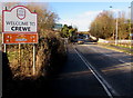
Welcome to Crewe - Home of Mornflake Oat Cereals
The sign is alongside the B5071 Gresty Road at the southern edge of Crewe.
Image: © Jaggery
Taken: 4 Feb 2017
0.16 miles