IMAGES TAKEN NEAR TO
Holmes Chapel Road, CONGLETON, CW12 4SS
Introduction
This page details the photographs taken nearby to Holmes Chapel Road, CW12 4SS by members of the Geograph project.
The Geograph project started in 2005 with the aim of publishing, organising and preserving representative images for every square kilometre of Great Britain, Ireland and the Isle of Man.

There are currently over 7.5m images from over14,400 individuals and you can help contribute to the project by visiting https://www.geograph.org.uk
Image Map
Images are licensed for reuse under creativecommons.org/licenses/by-sa/2.0
Notes
- Clicking on the map will re-center to the selected point.
- The higher the marker number, the further away the image location is from the centre of the postcode.
Image Listing (88 Images Found)
Images are licensed for reuse under creativecommons.org/licenses/by-sa/2.0
Image
Details
Distance
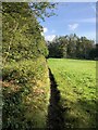
1
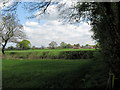
Towards Davenport
Looking along the northern boundary of Brereton Heath Country Park towards the hamlet of Davenport across the fields.
Image: © Jonathan Kington
Taken: 4 May 2010
0.06 miles
2
Behind the heath project (1)
Formerly a permissive path, this area behind the Image is now a struggle to get at, and through, because of overgrown brambles and bushes. This makes it a very peaceful place to be when Brereton Heath Country Park is busy. See also Image
Image: © Jonathan Kington
Taken: 9 Jul 2010
0.07 miles
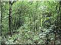
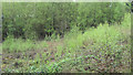
3
Behind the heath project (2)
Formerly a permissive path, this area behind the Image is now so difficult to get to very few people visit it. See also Image
Image: © Jonathan Kington
Taken: 9 Jul 2010
0.07 miles
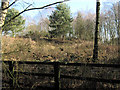
4
Hidden corner
Right at the back of Brereton Heath Country Park is this hidden, and hard to access, patch of woodland.
Image: © Jonathan Kington
Taken: 9 Jul 2010
0.08 miles
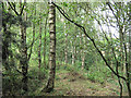
5

Secret corner
Because it is quite difficult to access, this little patch of woodland at the back of Brereton Heath Country Park is always a quiet place to visit.
Image: © Jonathan Kington
Taken: 9 Jul 2010
0.08 miles
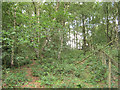
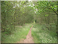
6
Footpath at Northern margin of Brereton Heath nature reserve
Image: © Philip Cornwall
Taken: 10 Oct 2021
0.09 miles
7
Clearing at the back of the park
In winter this clearing on the Western boundary of Brereton Heath Country Park, with its solitary Scots Pine, looks very bare. But in summer it will be a mass of Brambles and Rosebay Willowherb. The fence in the foreground marks the edge of the bridleway seen here Image and here Image
Image: © Jonathan Kington
Taken: 4 Mar 2010
0.09 miles
8
Lowland Heath project
Like the area in Image, this is also a project aimed at bringing back Lowland Heath to Brereton Heath Country Park which is an important habitat that is fast disappearing. The Birch saplings, Gorse, Rosebay Willowherb, Rhododendrons and Brambles will all be removed to allow the Heather to recover.
Image: © Jonathan Kington
Taken: 4 May 2010
0.10 miles
9
Eroded bridle path
The stepped bank on the left of the path shows how much the bridle path has been eroded over the years.
Image: © Jonathan Kington
Taken: 4 May 2010
0.10 miles
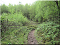
10
Looking east along the bridle path
Looking in an easterly direction along the bridle path behind the trees at the back of the main area of amenity grassland.
Image: © Jonathan Kington
Taken: 9 Jul 2010
0.10 miles