IMAGES TAKEN NEAR TO
Smithy Grove, SANDBACH, CW11 4XY
Introduction
This page details the photographs taken nearby to Smithy Grove, CW11 4XY by members of the Geograph project.
The Geograph project started in 2005 with the aim of publishing, organising and preserving representative images for every square kilometre of Great Britain, Ireland and the Isle of Man.

There are currently over 7.5m images from over14,400 individuals and you can help contribute to the project by visiting https://www.geograph.org.uk
Image Map
Images are licensed for reuse under creativecommons.org/licenses/by-sa/2.0
Notes
- Clicking on the map will re-center to the selected point.
- The higher the marker number, the further away the image location is from the centre of the postcode.
Image Listing (42 Images Found)
Images are licensed for reuse under creativecommons.org/licenses/by-sa/2.0
Image
Details
Distance
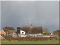
1
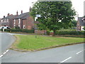
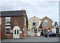
Hassall Green
The junction at the north end of Hassall Green, seen from the northeast. Off to the right is Betchton Road; Smithy Grove and the rest of the village to the left.
Image: © Derek Harper
Taken: 30 Jun 2006
0.07 miles
2
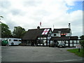
The Romping Donkey Pub, Hassall Green, Sandbach
Hassall Green SANDBACH CW11 4YA close to The Trent and Mersey Canal
Image: © canalandriversidepubs co uk
Taken: 12 Jun 2010
0.15 miles
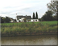
3
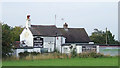
The Romping Donkey at Hassall Green, Cheshire
Seen from the Trent and Mersey Canal, the Romping Donkey is closed and boarded up. Whether that is due to the ineptness of Punch Taverns, who found they couldn't make enough profit quickly from a remote village hostelry, I know not.
It was originally called The Red Lion, built in the 17th century, and is Grade II listed.
Facebook postings (March 2012) suggest that it has been sold, the windows have been unboarded, and activity suggests it could well be re-opening as a pub quite soon. I hope so.
Image: © Roger D Kidd
Taken: 31 Aug 2011
0.15 miles
4
The Romping Donkey at Hassall Green, Cheshire
Seen from the Trent and Mersey Canal, the Romping Donkey is closed and boarded up. Whether that is due to the ineptness of Punch Taverns, who found they couldn't make enough profit quickly from a remote village hostelry, I know not.
Image: © Roger D Kidd
Taken: 31 Aug 2011
0.15 miles
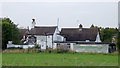
5
The former Romping Donkey at Hassall Green
At one time this was one of the best country pubs in the area. Another photo on this site shows it still open in 2010 Image Being a 17th century inn, it is also grade 2 listed (list entry number 1309973) and therefore could not easily be demolished. But in the last few years it has closed and become derelict.
Image: © Stephen Craven
Taken: 24 Dec 2014
0.15 miles
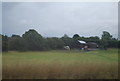
6
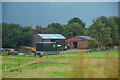
Betchton : Hassall Green
Looking towards some stables in the countryside.
Image: © Lewis Clarke
Taken: 27 Sep 2019
0.16 miles
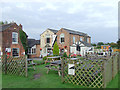
9
Canalside buildings at Hassall Green, Cheshire
The old buildings by paired locks No 57 have been well refurbished and are in business use including a well regarded restaurant (called Lock 57!) and shop.
Image: © Roger D Kidd
Taken: 31 Aug 2011
0.19 miles
10
Lockside restaurant seating at Hassall Green, Cheshire
The old buildings by paired locks No 57 have been well refurbished and are in business use including a well regarded licensed restaurant (called Lock 57!) and shop. The seating for restaurant patrons is on the filled in later of the two parallel locks (circa 1830).
Image: © Roger D Kidd
Taken: 31 Aug 2011
0.19 miles