IMAGES TAKEN NEAR TO
Bradwall, SANDBACH, CW11 1RB
Introduction
This page details the photographs taken nearby to CW11 1RB by members of the Geograph project.
The Geograph project started in 2005 with the aim of publishing, organising and preserving representative images for every square kilometre of Great Britain, Ireland and the Isle of Man.

There are currently over 7.5m images from over14,400 individuals and you can help contribute to the project by visiting https://www.geograph.org.uk
Image Map
Images are licensed for reuse under creativecommons.org/licenses/by-sa/2.0
Notes
- Clicking on the map will re-center to the selected point.
- The higher the marker number, the further away the image location is from the centre of the postcode.
Image Listing (25 Images Found)
Images are licensed for reuse under creativecommons.org/licenses/by-sa/2.0
Image
Details
Distance
1
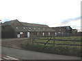
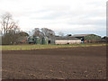
Springbank Farm from the road
The name of this farm is given on the Landranger map (both online and paper versions) as Sprinkbank, but it seems to be a rare OS error, as the Explorer map gives it as Springbank (as indeed it is on the farm's own nameplate).
Image: © Stephen Craven
Taken: 28 Dec 2008
0.00 miles
2
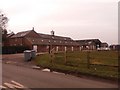
Springbank Farm with recent changes
Since I last photographed this farm over 7 years ago Image there have been some changes. The clock turret, although it looks historic, is new; there are additional skylight windows in the upper storey; and the silo has gone. The emphasis now seems to be on the livery stables.
The name of this farm is given on the Landranger map (both online and paper versions) as Sprinkbank, but it seems to be a rare OS error, as the Explorer map gives it as Springbank (as indeed it is on the farm's own nameplate). See also Image
Image: © Stephen Craven
Taken: 12 Mar 2016
0.01 miles
3
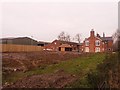
Springbank Farm from the south
The name of this farm is given on the Landranger map (both online and paper versions) as Sprinkbank, but it seems to be a rare OS error, as the Explorer map gives it as Springbank (as indeed it is on the farm's own nameplate). See also Image
Image: © Stephen Craven
Taken: 12 Mar 2016
0.03 miles
5
Springbank Farm from the rear
See a comment on the farm's name with the other view Image
Image: © Stephen Craven
Taken: 28 Dec 2008
0.03 miles
6
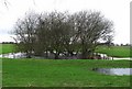
Small pond near Springbank Farm
After heavy rain the water level in this small pond has risen to overflow the depression in which it has formed. The pond is situated in a pasture of improved grassland.
Image: © Gill Stott
Taken: 12 Jan 2007
0.06 miles
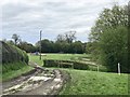
7
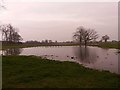
Flooded fields at Springbank Farm
Large scale maps do show a permanent pond in the nearest field, but after the very wet winter of 2015/6, it had swollen, and adjacent fields were also flooded. This is nothing new: see also Image
Image: © Stephen Craven
Taken: 12 Mar 2016
0.07 miles
9
Cross-country course at Bradwall Manor
Image: © Jonathan Hutchins
Taken: 29 Apr 2018
0.10 miles
10
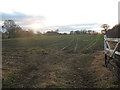
Early winter growth
This arable field had been ploughed and planted, with shoots already appearing by December, though too early for the non-expert to identify the crop.
Image: © Stephen Craven
Taken: 28 Dec 2008
0.11 miles