
IMAGES TAKEN NEAR TO
Eden Croft, KENILWORTH, CV8 2BG
Introduction
This page details the photographs taken nearby to Eden Croft, CV8 2BG by members of the Geograph project.
The Geograph project started in 2005 with the aim of publishing, organising and preserving representative images for every square kilometre of Great Britain, Ireland and the Isle of Man.

There are currently over 7.5m images from over14,400 individuals and you can help contribute to the project by visiting https://www.geograph.org.uk
Image Map
Images are licensed for reuse under creativecommons.org/licenses/by-sa/2.0
Notes
- Clicking on the map will re-center to the selected point.
- The higher the marker number, the further away the image location is from the centre of the postcode.
Image Listing (6 Images Found)
Images are licensed for reuse under creativecommons.org/licenses/by-sa/2.0
Image
Details
Distance
1
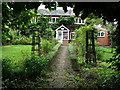
Thornby Cottage, 67 Windy Arbour, Kenilworth
A cottage which is older than all the houses around it - at the junction of Brooke Avenue. It is shown on the 1888 Ordnance Survey map and seems to be in the grounds of Thornby House, which was located about 100 yards further south, between here and the present day Thornby Avenue.
Image: © John Brightley
Taken: 30 Aug 2010
0.09 miles
2
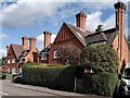
Tall chimneys on Windy Arbour
These two pairs of semi-detached houses form a striking contrast to the surrounding modern Kenilworth suburbia. I have not been able to find out anything about them. They have a Bournville, Arts & Crafts look to them, which would suggest a late 19th or early 20th century date, but they are not on the OS Six Inch map from that era. They look a bit too grand for estate cottages. Some of the chimneys lean alarmingly.
Image: © A J Paxton
Taken: 3 Oct 2023
0.10 miles
3
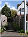
Suburban footpath, Windy Arbour
The path runs eastwards to Dencer Drive (via Narnia - see Image]), following the route it took when it was a path through fields, as the OS Six Inch map series shows.
Image: © A J Paxton
Taken: 3 Oct 2023
0.11 miles
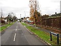
5
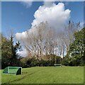
Field of dreams, Whitemoor, Kenilworth
This mini football pitch occupies part of an area of woodland and grass, surrounded by Kenilworth suburbia. Older Ordnance Survey maps show Whitemoor Brickworks on this site.
Image: © A J Paxton
Taken: 3 Oct 2023
0.17 miles
6
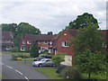
Housing Development
These houses were built in Kenilworth about 20 years ago and are now much sought-after as large, modern detached family homes.
Image: © David Williams
Taken: 28 May 2006
0.19 miles