IMAGES TAKEN NEAR TO
Black Bank, COVENTRY, CV7 9NX
Introduction
This page details the photographs taken nearby to Black Bank, CV7 9NX by members of the Geograph project.
The Geograph project started in 2005 with the aim of publishing, organising and preserving representative images for every square kilometre of Great Britain, Ireland and the Isle of Man.

There are currently over 7.5m images from over14,400 individuals and you can help contribute to the project by visiting https://www.geograph.org.uk
Image Map
Images are licensed for reuse under creativecommons.org/licenses/by-sa/2.0
Notes
- Clicking on the map will re-center to the selected point.
- The higher the marker number, the further away the image location is from the centre of the postcode.
Image Listing (15 Images Found)
Images are licensed for reuse under creativecommons.org/licenses/by-sa/2.0
Image
Details
Distance
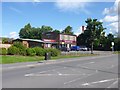
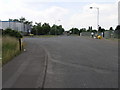
2
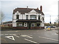
The Old Black Bank
Public house along Black Bank in Bedworth.
Image: © Mat Fascione
Taken: 28 Sep 2014
0.04 miles
3
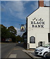
Exhall: The Old Black Bank Inn
The Old Black Bank Inn is on the B4113 at the boundary between Bedworth and Exhall. From the date in the gable the current pub dates from 1899, but the earliest large scale Ordnance Survey mapping currently available on line, dating from 1887, also shows a "Black Bank Inn", so evidently there was some form of beer house here serving the local mining community before the current pub was built.
The pub has got a very good, informative, and well laid out website here http://www.theoldblackbank.co.uk/
Image: © Nigel Cox
Taken: 31 Dec 2011
0.05 miles
4
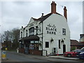
The Old Black Bank public house, Bedworth
On Black Bank.
Image: © JThomas
Taken: 11 Mar 2017
0.05 miles
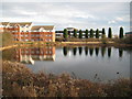
5

Black Bank, lake
Possibly connected with the former nearby Exhall Colliery, the lake is shown on Victorian OS maps; it is now a source of local plant and birdlife. Residential buildings on The Waterfront to the left.
Image: © Mike Faherty
Taken: 8 Jun 2014
0.05 miles
6
Black Bank, Sainsbury's Local
On Exhall.
Image: © Mike Faherty
Taken: 8 Jun 2014
0.07 miles
7
Exhall: Black Bank Pool
The pool is shown on the earliest edition of the large scale Ordnance Survey mapping currently available on line, dating from 1887, although to a stranger its origins are not clear. Did it have a function connected with the nearby Exhall Colliery, or the local brickmaking industry, or is it a naturally occurring feature?
Trying to research its origins on the internet it appears that the new residential development on the left was a source of much discontent amongst various parties in the 2000s.
Image: © Nigel Cox
Taken: 31 Dec 2011
0.07 miles
8
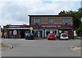
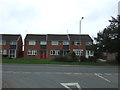
Sainsbury's Local along Coventry Road Exhall
This used to be The Orchard public house, which closed in 2012.
Image: © Mat Fascione
Taken: 28 Sep 2014
0.08 miles
9
Black Bank, industrial estate
Bayton Road Industrial Estate, on Colliery Lane, site of a former colliery.
Image: © Mike Faherty
Taken: 8 Jun 2014
0.10 miles
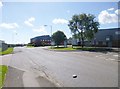
10
Industry Meets Housing
The housing at the top of Colliery Lane North marks the edge of the Beyton Road industrial area.
Image: © Michael Patterson
Taken: 3 Jul 2006
0.11 miles