IMAGES TAKEN NEAR TO
Hanford Close Industrial Estate, Stoney Stanton Road, COVENTRY, CV6 5TL
Introduction
This page details the photographs taken nearby to Hanford Close Industrial Estate, Stoney Stanton Road, CV6 5TL by members of the Geograph project.
The Geograph project started in 2005 with the aim of publishing, organising and preserving representative images for every square kilometre of Great Britain, Ireland and the Isle of Man.

There are currently over 7.5m images from over14,400 individuals and you can help contribute to the project by visiting https://www.geograph.org.uk
Image Map
Images are licensed for reuse under creativecommons.org/licenses/by-sa/2.0
Notes
- Clicking on the map will re-center to the selected point.
- The higher the marker number, the further away the image location is from the centre of the postcode.
Image Listing (41 Images Found)
Images are licensed for reuse under creativecommons.org/licenses/by-sa/2.0
Image
Details
Distance
1
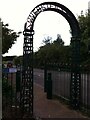
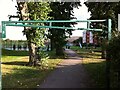
Entrance to Webster's Park, Foleshill, Coventry
This is the pedestrian entrance from Stoney Stanton Road to Webster's Park, which has been laid out on part of the former Webster's brickworks site.
Image: © A J Paxton
Taken: 26 Aug 2021
0.05 miles
2
Stoney Stanton Road, seen from the entrance to Webster's Park
This is the view from the gate to Webster's Park, looking out to Stoney Stanton Road at the junction with Bright Street.
Image: © A J Paxton
Taken: 26 Aug 2021
0.06 miles
3
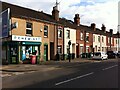
Stoney Stanton Road, Coventry, viewed from the entrance to Webster's Park
This row of houses on Stoney Stanton Road is part of the development laid out in the 1850s by the Coventry & Warwickshire Artizans Freehold Land Society, which was established in 1851. Freehold Land Societies aimed to make home ownership available to working men, who as householders would then also have the right to vote. Freehold Street in Hillfields was another Coventry example - see here Image
A member of the Coventry & Warwickshire Artizans Freehold Land Society could be allocated one of 262 plots on which to build a house. The member would then pay the society back over a number of years. This project does not appear to have been as successful as some other such societies in Coventry, and some plots were bought up in blocks by developers and built on. The area later suffered heavy bomb damage in the second world war. See Fry, D & Smith, A, The Coventry we have lost: Forgotten Foleshill, Simanda Press, Berkswell, pp91-92.
Image: © A J Paxton
Taken: 26 Aug 2021
0.07 miles
4
Ghost Town, Forty Years On
An advert for The Specials' UK Tour 2021 can be seen pasted on the side of a phone box on Stoney Stanton Road, Coventry, near the junction with St Paul's Road, with the tower block Falkener House visible in the distance. The house behind the phone box and to the left is a mosque, as is evident from the sign on the front showing a green dome and minaret.
The photo was taken in August 2021, forty years after the Coventry two-tone ska & reggae band The Specials had a no. 1 hit with their song Ghost Town, describing the economic decline, urban decay and rising youth anger in Coventry and other British cities where they had toured https://en.wikipedia.org/wiki/Ghost_Town_(Specials_song) .
Image: © A J Paxton
Taken: 26 Aug 2021
0.07 miles
5

Graffiti, Red House Park, Coventry
The graffiti has been painted on a factory wall on the south side of the park.
Image: © A J Paxton
Taken: 26 Aug 2021
0.07 miles
6
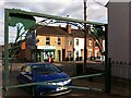
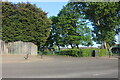
Red House Park, Stoney Stanton Road, Foleshill
Red House Park is a well-used green space in this very built-up area of Coventry. It takes its name from the Red House public house which stood on Stoney Stanton Road, to the right of this picture. Later known as Fatty Arbuckle's, it closed in 1995 and the blocks of flats called Rathbone Court, visible at the right hand side of this photo, was built on the site. The OS Six Inch Map of 1912 shows a football ground where the park now stands. See Fry, D & Smith A: The Coventry we have lost: Forgotten Foleshill, Simanda Press, 2018, pp93-94. The OS 1:10560 series map of 1949-1970 shows allotments at the rear, adjoining Freeman Street, now also part of the park https://maps.nls.uk/geo/explore/side-by-side/#zoom=17&lat=52.42442&lon=-1.49287&layers=193&right=OSAPI .
Image: © A J Paxton
Taken: 26 Aug 2021
0.07 miles
8
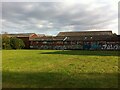
Red House Park, Foleshill, with factory buildings beyond
This is a view of part of Red House Park on Stoney Stanton Road, Coventry, looking southwards to the factory buildings located between the park, Oliver Street and Cromwell Street. This district of Coventry was dominated by the Coventry Ordnance Works, an armaments factory, which closed in 1925, although some of its buildings survive. The factory buildings in this photo are not marked on the OS Six Inch map of 1912; if they were part of the ordnance works they were built after that date, perhaps during the first world war. https://maps.nls.uk/geo/explore/side-by-side/#zoom=17&lat=52.42371&lon=-1.49354&layers=10&right=OSAPI
For more on Red House Park see Image For a detail of the graffiti on the wall, see Image For more on the Coventry Ordnance Works see Image
Image: © A J Paxton
Taken: 26 Aug 2021
0.08 miles
9
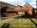
St Barnabas Church of Masihi Sandesh and Community Centre, Cromwell Street, Foleshill, Coventry
St Barnabas was built in 1933 by the Church of England, the fruit of a mission begun almost forty years earlier in what was then a rapidly expanding industrial district of the city; see the Victoria County History of Warwickshire Vol 8 pp361-7 https://www.british-history.ac.uk/vch/warks/vol8/pp361-367 . Today it belongs to a Christian community of Indian heritage. 'Masihi' means 'Christian' in Hindi (and also in Urdu and Persian).
Image: © A J Paxton
Taken: 26 Aug 2021
0.10 miles
10

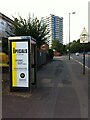
MOT Centre Services on Stoney Stanton Road, Foleshill
Image: © David Howard
Taken: 21 May 2023
0.10 miles