IMAGES TAKEN NEAR TO
Station Street East, COVENTRY, CV6 5FN
Introduction
This page details the photographs taken nearby to Station Street East, CV6 5FN by members of the Geograph project.
The Geograph project started in 2005 with the aim of publishing, organising and preserving representative images for every square kilometre of Great Britain, Ireland and the Isle of Man.

There are currently over 7.5m images from over14,400 individuals and you can help contribute to the project by visiting https://www.geograph.org.uk
Image Map (Loading...)


Getting Data...Please wait
Leaflet Map data © OpenStreetMap
Images are licensed for reuse under creativecommons.org/licenses/by-sa/2.0
Notes
- Clicking on the map will re-center to the selected point.
- The higher the marker number, the further away the image location is from the centre of the postcode.
Image Listing (46 Images Found)
Images are licensed for reuse under creativecommons.org/licenses/by-sa/2.0
Image
Details
Distance
1
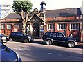
Coventry- Paradise Foleshill
The Sign on the wall of this old School building says Paradise Day Centre. It is unclear if this building is still in use.
Image: © Ian Rob
Taken: 9 Jan 2008
0.08 miles
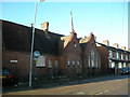
2
Adult Education Centre, Broad Street, Foleshill, Coventry
The centre occupies the buildings of the Broad Street school, which opened in 1911 and became Broad Heath School in 1949 (Fry, D & Smith, A, The Coventry we have lost: Forgotten Foleshill, Simanda Press, 2018, p36).
Image: © A J Paxton
Taken: 26 Aug 2021
0.08 miles
3
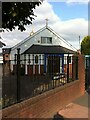
St Elizabeth's Roman Catholic Church, Foleshill, Coventry
View from St Elizabeth's Road, Foleshill. The junction with Eld Road is just out of shot to the right.
Image: © John Curran
Taken: 13 Feb 2010
0.09 miles
4
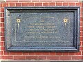
Plaque on Broad Street Library, Foleshill, Coventry
Plaque erected in 1912 on Broad Street Library, one of three Coventry library buildings funded by the Carnegie Foundation; the others are on Walsgrave Road in Stoke and on Earlsdon Avenue North in Earlsdon.
Image: © A J Paxton
Taken: 16 Aug 2021
0.13 miles
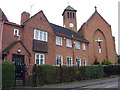
5
Broad Street Library, Foleshill, Coventry
One of three Carnegie libraries in Coventry; the others are on Earlsdon Avenue North in Earlsdon and on Walsgrave Road in Stoke.
Carnegie libraries were built with money given by the Scottish-American business magnate Andrew Carnegie; over 2000 were constructed between 1886 and 1929, 660 of them in Britain & Ireland. The libraries were an expression of his belief in self-help and were deliberately built in prominent public places, typically with a grand entrance with steps, symbolising the raising up of the reader through learning. https://en.wikipedia.org/wiki/Carnegie_library
The city of Coventry approached Carnegie and his foundation in 1910 for funding to build three branch libraries, and was awarded £10000, on condition the city provided the land and an additional rate (tax) to fund the running of the libraries, which it did the following year. https://www.coventry.gov.uk/downloads/file/20370/req00916 The Coventry libraries are built in red brick with sandstone dressings in a baroque style. They are all still in use as public libraries.
Broad Street Library was burned down by arsonists in 2003 and most of the stock - which included the city's main collection of multicultural library books and materials - was destroyed. The library was subsequently rebuilt and restocked. See this Coventry Telegraph report https://www.coventrytelegraph.net/news/coventry-news/libraries-set-2m-new-chapter-3147790 .
Image: © A J Paxton
Taken: 16 Aug 2021
0.13 miles
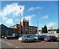
6
Coventry-Broad Street
The Church of Saint Vladimir The Great, which is Ukrainian Catholic Eastern Rite.
Image: © Ian Rob
Taken: 9 Jan 2008
0.13 miles
7
Ukrainian Catholic Church of St Wolodymyr the Great, Broad Street, Foleshill, Coventry
This church building opened in 1962 and stands on the site of a Wesleyan chapel that was built in 1839 and destroyed in the second world war. After 1945 the Methodists built on its site a wooden chapel which may form the basis of the current building; see the Victoria County History of Warwickshire Vol 8 pp382-396 https://www.british-history.ac.uk/vch/warks/vol8/pp382-396#h3-0017 .
Ukrainians settled in Coventry during and after the second world war, driven from their homeland by war and political persecution. Many were Catholics of the eastern or Byzantine rite, in communion with the Roman Catholic Church but worshipping according to a liturgy much closer to that of the Orthodox Church. Masses according to this rite were celebrated in Catholic parish churches in Coundon and later Foleshill until this church was built (ibid. pp368-371 https://www.british-history.ac.uk/vch/warks/vol8/pp368-371 )
St Wolodymyr is better known in the west by the Russian form of his name, Vladimir. He was a pagan ruler of Kyivan Rus', which encompassed peoples living in parts of what is now Ukraine, Belarus and Russia. His conversion to Christianity in the year 988 led to their becoming Christians. https://en.wikipedia.org/wiki/Vladimir_the_Great
Image: © A J Paxton
Taken: 26 Aug 2021
0.13 miles
8
Coventry-Gurdwara Sri Guru Singh Sabha
Sikh Temple in Cross Road.
Image: © Ian Rob
Taken: 24 Feb 2014
0.13 miles
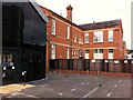
9
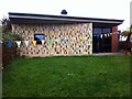
Broad Street Library, Foleshill, seen from the rear
Broad Street Library is one of three built in Coventry in 1911-12 with funds provided by the Carnegie Foundation. For a fuller description and a photo of the building as seen from the street, see here Image The library was rebuilt after an arson attack in 2003, and this extension has presumably been added since then. The lawn is used for storytelling sessions for young children. The small dome or turret belongs to the original Carnegie building.
Image: © A J Paxton
Taken: 26 Aug 2021
0.14 miles
10
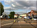
Junction of Broad Street & Stoney Stanton Road, Foleshill, Coventry
Broad Street, under its older name of Brick Kiln Lane, and Stoney Stanton Road were roads in the rural parish of Foleshill, which was settled by ribbon weavers and coal miners in the 18th and 19th centuries. The area was incorporated into Coventry in 1899, by which time it was rapidly being built up. (Fry, D & Smith, A, The Coventry we have lost: Forgotten Foleshill, Simanda Press, 2018, p23).
To the left in this picture, and with a small golden dome, can be seen the Ukrainian Catholic Church of St Wolodymyr, on the site of a Wesleyan chapel that was destroyed in the second world war Image On the far side of Stoney Stanton Road stands the building formerly occupied by Purewall Wines, which still carries the ghost of an advertisement for the corn merchant that occupied the premises in the earlier 20th century Image
The junction is overlooked by the 17-storey Falkener House block of flats, built by the city council and completed in 1968. Though not visible here, as it is behind the photographer, it can be seen in this geograph Image
Image: © A J Paxton
Taken: 26 Aug 2021
0.14 miles