Junction of Broad Street & Stoney Stanton Road, Foleshill, Coventry
Introduction
The photograph on this page of Junction of Broad Street & Stoney Stanton Road, Foleshill, Coventry by A J Paxton as part of the Geograph project.
The Geograph project started in 2005 with the aim of publishing, organising and preserving representative images for every square kilometre of Great Britain, Ireland and the Isle of Man.

There are currently over 7.5m images from over 14,400 individuals and you can help contribute to the project by visiting https://www.geograph.org.uk
Junction of Broad Street & Stoney Stanton Road, Foleshill, Coventry
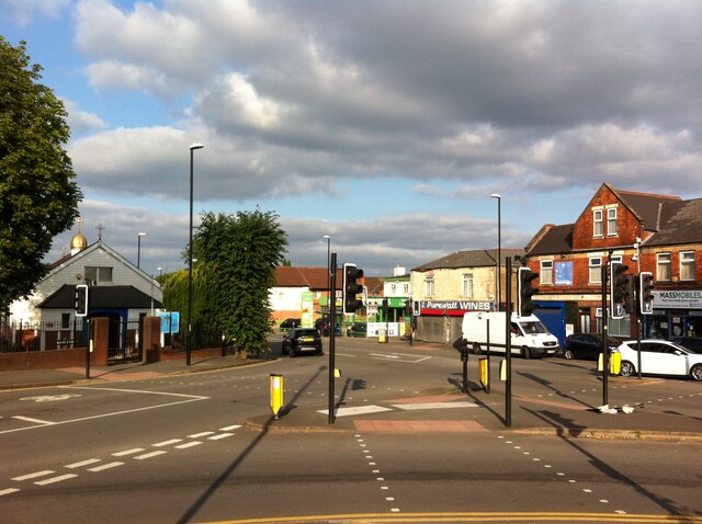
Image: © A J Paxton Taken: 26 Aug 2021
Broad Street, under its older name of Brick Kiln Lane, and Stoney Stanton Road were roads in the rural parish of Foleshill, which was settled by ribbon weavers and coal miners in the 18th and 19th centuries. The area was incorporated into Coventry in 1899, by which time it was rapidly being built up. (Fry, D & Smith, A, The Coventry we have lost: Forgotten Foleshill, Simanda Press, 2018, p23). To the left in this picture, and with a small golden dome, can be seen the Ukrainian Catholic Church of St Wolodymyr, on the site of a Wesleyan chapel that was destroyed in the second world war Image On the far side of Stoney Stanton Road stands the building formerly occupied by Purewall Wines, which still carries the ghost of an advertisement for the corn merchant that occupied the premises in the earlier 20th century Image The junction is overlooked by the 17-storey Falkener House block of flats, built by the city council and completed in 1968. Though not visible here, as it is behind the photographer, it can be seen in this geograph Image
Images are licensed for reuse under creativecommons.org/licenses/by-sa/2.0
Image Location
Latitude
52.426617
Longitude
-1.492734