IMAGES TAKEN NEAR TO
Stoney Stanton Road, COVENTRY, CV6 5ED
Introduction
This page details the photographs taken nearby to Stoney Stanton Road, CV6 5ED by members of the Geograph project.
The Geograph project started in 2005 with the aim of publishing, organising and preserving representative images for every square kilometre of Great Britain, Ireland and the Isle of Man.

There are currently over 7.5m images from over14,400 individuals and you can help contribute to the project by visiting https://www.geograph.org.uk
Image Map (Loading...)


Getting Data...Please wait
Leaflet Map data © OpenStreetMap
Images are licensed for reuse under creativecommons.org/licenses/by-sa/2.0
Notes
- Clicking on the map will re-center to the selected point.
- The higher the marker number, the further away the image location is from the centre of the postcode.
Image Listing (34 Images Found)
Images are licensed for reuse under creativecommons.org/licenses/by-sa/2.0
Image
Details
Distance
1
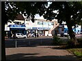
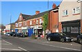
Discount Warehouse store, Stoney Stanton Road, Foleshill, Coventry
The Discount Warehouse and its neighbour, the Ali Baba Fish Bar & Kebab House, stand near the bend in Stoney Stanton Road (visible to the right) and are viewed from the forecourt of Falkener House, a housing tower block.
Image: © A J Paxton
Taken: 26 Aug 2021
0.01 miles
2
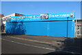
New Cheap Tyres on Stoney Stanton Road, Foleshill
Image: © David Howard
Taken: 21 May 2023
0.02 miles
3
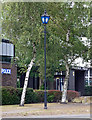
Police lamp, Stoney Stanton Road, Coventry
Quite a rare sight nowadays. It stands outside Foleshill Police Station.
Image: © Stephen Richards
Taken: 22 Aug 2011
0.02 miles
4
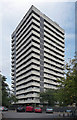
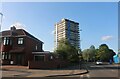
Falkener House, Stoney Stanton Road, Coventry
One of a number of similarly-styled tower blocks dotted about the northern fringes of Coventry, standing like sentries as if to provide early warning of incursions by Nuneaton or Hinckley. They are distinguished by projecting white concrete bands and closely resemble designs by City Architect, Arthur Ling. Built 1961.
Image: © Stephen Richards
Taken: 22 Aug 2011
0.04 miles
5

MOT Centre Services on Stoney Stanton Road, Foleshill
Image: © David Howard
Taken: 21 May 2023
0.04 miles
7
Tower block on Stoney Stanton Road, Edgwick
It's called Falkland House and has one or two copies nearby.
Image: © David Howard
Taken: 21 May 2023
0.05 miles
9
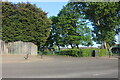
Red House Park, Stoney Stanton Road, Foleshill
Red House Park is a well-used green space in this very built-up area of Coventry. It takes its name from the Red House public house which stood on Stoney Stanton Road, to the right of this picture. Later known as Fatty Arbuckle's, it closed in 1995 and the blocks of flats called Rathbone Court, visible at the right hand side of this photo, was built on the site. The OS Six Inch Map of 1912 shows a football ground where the park now stands. See Fry, D & Smith A: The Coventry we have lost: Forgotten Foleshill, Simanda Press, 2018, pp93-94. The OS 1:10560 series map of 1949-1970 shows allotments at the rear, adjoining Freeman Street, now also part of the park https://maps.nls.uk/geo/explore/side-by-side/#zoom=17&lat=52.42442&lon=-1.49287&layers=193&right=OSAPI .
Image: © A J Paxton
Taken: 26 Aug 2021
0.07 miles
10
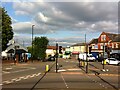
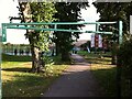
Junction of Broad Street & Stoney Stanton Road, Foleshill, Coventry
Broad Street, under its older name of Brick Kiln Lane, and Stoney Stanton Road were roads in the rural parish of Foleshill, which was settled by ribbon weavers and coal miners in the 18th and 19th centuries. The area was incorporated into Coventry in 1899, by which time it was rapidly being built up. (Fry, D & Smith, A, The Coventry we have lost: Forgotten Foleshill, Simanda Press, 2018, p23).
To the left in this picture, and with a small golden dome, can be seen the Ukrainian Catholic Church of St Wolodymyr, on the site of a Wesleyan chapel that was destroyed in the second world war Image On the far side of Stoney Stanton Road stands the building formerly occupied by Purewall Wines, which still carries the ghost of an advertisement for the corn merchant that occupied the premises in the earlier 20th century Image
The junction is overlooked by the 17-storey Falkener House block of flats, built by the city council and completed in 1968. Though not visible here, as it is behind the photographer, it can be seen in this geograph Image
Image: © A J Paxton
Taken: 26 Aug 2021
0.07 miles