IMAGES TAKEN NEAR TO
Birkdale Close, COVENTRY, CV6 4PJ
Introduction
This page details the photographs taken nearby to Birkdale Close, CV6 4PJ by members of the Geograph project.
The Geograph project started in 2005 with the aim of publishing, organising and preserving representative images for every square kilometre of Great Britain, Ireland and the Isle of Man.

There are currently over 7.5m images from over14,400 individuals and you can help contribute to the project by visiting https://www.geograph.org.uk
Image Map
Images are licensed for reuse under creativecommons.org/licenses/by-sa/2.0
Notes
- Clicking on the map will re-center to the selected point.
- The higher the marker number, the further away the image location is from the centre of the postcode.
Image Listing (15 Images Found)
Images are licensed for reuse under creativecommons.org/licenses/by-sa/2.0
Image
Details
Distance
1
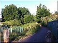
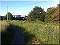
Path from Blenheim Walk to Houldsworth Crescent, Holbrooks, Coventry
The path runs alongside overgrown allotments to the right and a stream overhung with trees to the left. The railings to the left fence off a steep drop to where the stream emerges from a culvert.
Image: © A J Paxton
Taken: 15 Jun 2021
0.03 miles
2
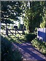
Gate to Houldsworth Crescent allotments, Holbrooks, Coventry
Though allotments sites in Coventry are generally well-used, these seem increasingly overgrown and derelict. To become another housing site, perhaps. A path runs round the side to more housing and then to Prologis Park.
Image: © A J Paxton
Taken: 15 Jun 2021
0.12 miles
3
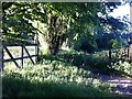
Path around edge of allotments behind Houldsworth Crescent, Holbrooks
The gate to the allotments is to the left, the gate to the path straight ahead. The path turns to the left almost immediately and runs along the side of the allotments, which are bordered by a row of Lombardy poplars. To the right of the path is a small stream that emerges from a culvert among trees. The path continues to Blenheim Walk, a suburban street, then joins the Rookery Lane-Blackberry Lane path that crosses the disused mineral line and the approach road to Prologis Park and continues to Ash Green.
Image: © A J Paxton
Taken: 15 Jun 2021
0.12 miles
4
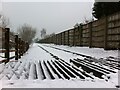
Mineral line in the snow
The photo shows the crossing where the Blackberry Lane footpath passes over the mineral line, as it appeared on a snowy day in January 2021. The line was built to connect Coventry Colliery (see here Image]) to the railway line from Coventry to Nuneaton. This photo shows the view eastwards towards the main line. The track has been preserved and incorporated into the Prologis Park business estate which occupies the site of the colliery, but it has not been used for rail traffic and a fence now crosses the line by this crossing, to discourage trespassers.
Image: © A J Paxton
Taken: 24 Jan 2021
0.12 miles
5
Footpath along approximate route of Rookery Lane
Rookery Lane ran from Rookery Farm in Keresley to the crossroads in Ash Green, where it crossed Wheelwright Lane and joined what is now St. Giles Road, but was then Dead Lane (perhaps because the dead were carried that way to their final resting place in St. Giles churchyard). A track continued south from Rookery Farm to Nunts Lane. This, at least, is the picture given by the OS Six Inch maps of the 1888-1913 series. https://maps.nls.uk/geo/explore/side-by-side/#zoom=17&lat=52.45525&lon=-1.51101&layers=6&right=OSAPI
The landscape was subsequently rearranged by the building of Coventry colliery, now the site of Prologis Park, and by the advance of suburban Coventry. The northern section of the lane, from Ash Green to the edge of Prologis Park has become Blackberry Lane. Rookery Farm has disappeared under the grounds of President Kennedy school, while the track to Nunts Lane has become a built-up, suburban Rookery Lane. In between these two roads, paths run among trees around the edge of Prologis Park. The building with the 'broken pediment' roof is Ashbrook Court, a Prologis Park office block built around 2004.
Image: © A J Paxton
Taken: 15 Jun 2021
0.15 miles
6
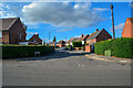
Coventry : Meadow Road
Looking along Meadow Road.
Image: © Lewis Clarke
Taken: 25 Sep 2021
0.18 miles
7
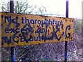
NCB sign by mineral rail line on perimeter of Prologis Park, Keresley, Coventry
The NCB was the National Coal Board, the statutory corporation which ran the state-owned coal mining industry of the UK from 1947 to 1987, prior to the selling-off of the remaining assets. The Prologis business park occupies the site of the Coventry Colliery, which closed in 1991, and the Homefire smokeless fuel plant, which closed in 2000. https://en.wikipedia.org/wiki/Coventry_Colliery
Image: © A J Paxton
Taken: 20 Apr 2021
0.19 miles
8

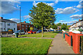
Coventry : Nunts Lane
A residential road.
Image: © Lewis Clarke
Taken: 25 Sep 2021
0.20 miles
9
Coventry : Nunts Lane
Looking along Nunts Lane.
Image: © Lewis Clarke
Taken: 25 Sep 2021
0.22 miles
10
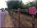
Maganterulent! Belepni Tilos!
On a roadside fence in Coventry a sign in Hungarian warns that the land behind it is private and to keep out. Similar signs in many languages once adorned this stretch of fence. Many have disappeared, removed perhaps by souvenir hunters, but signs remain in English, Italian, Lithuanian and Polish as well as Hungarian. The road forms the approach to an industrial park. Long distance lorry drivers parked up here frequently, and perhaps some relieved themselves behind the fence.
Image: © A J Paxton
Taken: 19 Aug 2022
0.23 miles