IMAGES TAKEN NEAR TO
Selworthy Road, COVENTRY, CV6 4JG
Introduction
This page details the photographs taken nearby to Selworthy Road, CV6 4JG by members of the Geograph project.
The Geograph project started in 2005 with the aim of publishing, organising and preserving representative images for every square kilometre of Great Britain, Ireland and the Isle of Man.

There are currently over 7.5m images from over14,400 individuals and you can help contribute to the project by visiting https://www.geograph.org.uk
Image Map (Loading...)


Getting Data...Please wait
Leaflet Map data © OpenStreetMap
Images are licensed for reuse under creativecommons.org/licenses/by-sa/2.0
Notes
- Clicking on the map will re-center to the selected point.
- The higher the marker number, the further away the image location is from the centre of the postcode.
Image Listing (25 Images Found)
Images are licensed for reuse under creativecommons.org/licenses/by-sa/2.0
Image
Details
Distance
1
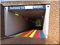
Subway to the Arena
This pedestrian subway leads under the A444 Jimmy Hill Way, connecting a car park to the Arena stadium and the adjoining railway station and shopping mall. The sign probably once said 'Ricoh Arena', but 'Ricoh' has been overpainted, as the company no longer sponsors the stadium, which is now the Coventry Building Society Arena. The rainbow lights and stripes are a recent addition in 2022, perhaps in preparation for the Commonwealth Games, as some of the events will be taking place in the stadium.
Image: © A J Paxton
Taken: 18 Jul 2022
0.15 miles
2
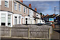
St Luke's Road, Holbrooks
The terraced houses on the left are caught by a burst of sunshine; one of them has recently been sold through Yopa. The 'no through road' sign is here because vehicular access to Hen Lane is blocked off.
Image: © Stephen McKay
Taken: 18 Nov 2022
0.17 miles
3

England - all welcome
You are welcome here - if you can get past the owl.
This was the former offices of City Gearboxes (Cov) Ltd on St Luke's Road in Holbrooks, Coventry.
Image: © A J Paxton
Taken: 26 Apr 2019
0.17 miles
4
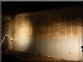
Phoenix Way Tunnel North Retaining Wall
Taken during authorised access to the railway as part of an inspection of the structure.
Image: © Richard Cooke
Taken: 12 Feb 2012
0.18 miles
5
Coventry-Phoenix Way
Looking from the footbridge towards the car park where there is a funfair this week end.
Image: © Ian Rob
Taken: 4 Jun 2011
0.18 miles
6

Phoenix Way Tunnel South Retaining Wall
Taken during authorised access to the railway as part of an inspection of the structure.
Image: © Richard Cooke
Taken: 12 Feb 2012
0.18 miles

8
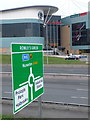
Coventry: A444 road sign and the Ricoh Arena
The direction sign is green because it is a primary route (trunk road) and is therefore marked in green on road atlases. The white panels for the side-road destinations denote that these are local names on non-primary routes; these would previously have been on a separate sign white in colour, but the system was changed a few years ago.
In the background is the main entrance to Image
Image: © Chris Downer
Taken: 23 Nov 2013
0.21 miles
9
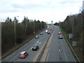
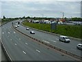
Phoenix Way (A444)
Looking north east from the bridge on Lythalls Lane.
Image: © JThomas
Taken: 4 Mar 2017
0.21 miles
10
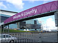
Welcome to Coventry
During the 2012 Olympics, the Ricoh Arena was renamed the City of Coventry Stadium and hosted preliminary round football matches. The footbridge over the A444 was covered in Olympic livery. Here it is viewed from the north.
Image: © Niki Walton
Taken: 4 Jul 2012
0.22 miles