1
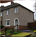
Heathcote Street, Radford, Coventry
Heathcote Street is a dead end street (though crossed by other roads), but will be familiar to anyone who has attended, or whose children have attended, one of the two primary schools near its far end, Hill Farm and St. Augustine's, a Catholic school. On the right hand side, and extending off the picture into Bulwer Road, are a group of houses whose brick facades have grand 'wild west' parapets concealing the conventional pitched roof behind. The corner house, with its array of wheelie bins, has been executed in blue engineering bricks.
Image: © A J Paxton
Taken: 9 Jun 2021
0.06 miles
2
Looking down Beake Avenue from Radford Common
Image: © Niki Walton
Taken: 12 Oct 2007
0.07 miles
3
Radford Common, Radford Road
Looking across the new play area on Radford Common to Radford Road (B4098).
Image: © Niki Walton
Taken: 12 Oct 2007
0.09 miles
4
Monarch Pharmacy, Radford Road
Now occupying the whole of this newly-built premises, Monarch Pharmacy originally occupied the right corner of the previous building before expanding. Other businesses in the building previously on this site included a veterinary practice (now a few doors further along Radford Road), a wool & crafts shop and a refrigerator/freezer retailer & repairer.
Image: © Niki Walton
Taken: 12 Oct 2007
0.11 miles
5
Benchmark on #263 Radford Road
Ordnance Survey cut mark benchmark levelled at 102.684m above Newlyn Datum
Image: © Roger Templeman
Taken: 30 Apr 2018
0.12 miles
6
#263 Radford Road
There is an OS benchmark
Image on the near corner, right hand face, of the house
Image: © Roger Templeman
Taken: 30 Apr 2018
0.12 miles
7
Steps, Radford Common
Three shallow steps leading from Engleton Road to Radford Common.
Image: © Niki Walton
Taken: 12 Oct 2007
0.13 miles
8
Villa Road, Radford
A plaque on the house out of shot, left, says 'Villa Road Terrace 1898'. The postbox ID is CV6 156.
Image: © Robin Stott
Taken: 16 Apr 2010
0.14 miles
9
Radford Common
Coventry's commons became public open spaces by Act of Parliament in 1927. This is the southeast corner of a once much more extensive common, seen across Engleton Road at its junction with Radford Road. The level ground nearest the road was the original site of the Radford war memorial
Image In the 1980s, because of increasing damage and because the ground could be muddy for the Remembrance ceremony in November, the memorial was moved to a position nearer St Nicholas Church, behind the camera
Image
Image: © Robin Stott
Taken: 16 Apr 2010
0.15 miles
10
The War Memorial, Radford
Image: © Ian S
Taken: 25 Dec 2013
0.15 miles


