IMAGES TAKEN NEAR TO
Watery Lane, COVENTRY, CV6 2GH
Introduction
This page details the photographs taken nearby to Watery Lane, CV6 2GH by members of the Geograph project.
The Geograph project started in 2005 with the aim of publishing, organising and preserving representative images for every square kilometre of Great Britain, Ireland and the Isle of Man.

There are currently over 7.5m images from over14,400 individuals and you can help contribute to the project by visiting https://www.geograph.org.uk
Image Map (Loading...)


Getting Data...Please wait
Leaflet Map data © OpenStreetMap
Images are licensed for reuse under creativecommons.org/licenses/by-sa/2.0
Notes
- Clicking on the map will re-center to the selected point.
- The higher the marker number, the further away the image location is from the centre of the postcode.
Image Listing (12 Images Found)
Images are licensed for reuse under creativecommons.org/licenses/by-sa/2.0
Image
Details
Distance
2
Recent neo-vernacular housing seen from field by Watery Lane
Early 21st century suburban houses in vernacular cottage style, the advancing front of the built-up area of Coventry, seen from a field on the city's edge.
Image: © A J Paxton
Taken: 15 Jun 2021
0.06 miles
3
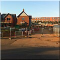
New housing, Watery Lane, Holbrooks
Housing developments are now filling in the gaps in the built-up area around Holbrooks and Keresley. This one on Watery Lane has been called 'Jubilee Green' by the developer. Behind it can be seen part of President Kennedy school.
Image: © A J Paxton
Taken: 9 Aug 2022
0.07 miles
4
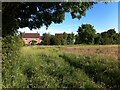
Unofficial path near Hall Brook, edge of Holbrooks and Keresley, Coventry
Heading in the direction of Watery Lane, which lies beyond the hedge. A walk to be enjoyed before this land is built on.
Image: © A J Paxton
Taken: 15 Jun 2021
0.08 miles
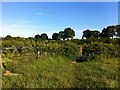
6
Keresley Jubilee Wood viewed from Watery Lane
Keresley Jubilee Wood is a community woodland in the parish of Keresley on the edge of Coventry, an area that is rapidly being built up. Since 2012 the wood has been planted with 3 hectares of native trees; see Image
Image: © A J Paxton
Taken: 29 Dec 2022
0.12 miles
7
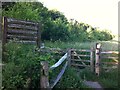
Keresley Jubilee Wood
The entrance to Keresley Jubilee Wood, a community woodland which has been planted with 3 hectares of native trees since 2012 and is managed by Coventry City Council.
Image: © A J Paxton
Taken: 15 Jun 2021
0.14 miles
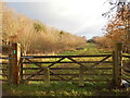
8
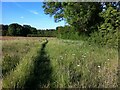
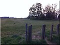
Gate and kissing gate by Hall Brook, Keresley
These fields between Keresley and Holbrooks have effectively open access to walkers, at least until houses are built on them, their likely fate. The edge of the Coventry built-up area can be seen at the left of the photo.
Image: © A J Paxton
Taken: 15 Jun 2021
0.15 miles
9
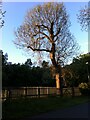
Last rays of setting sun against tree and fence stakes, Watery Lane, Keresley
Image: © A J Paxton
Taken: 25 May 2021
0.18 miles
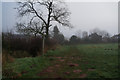
10
Walking the dog in fields off Watery Lane, Keresley
Looking towards Bennetts Road
Image: © A J Paxton
Taken: 20 Apr 2021
0.18 miles