IMAGES TAKEN NEAR TO
Lammas Road, COVENTRY, CV6 1QA
Introduction
This page details the photographs taken nearby to Lammas Road, CV6 1QA by members of the Geograph project.
The Geograph project started in 2005 with the aim of publishing, organising and preserving representative images for every square kilometre of Great Britain, Ireland and the Isle of Man.

There are currently over 7.5m images from over14,400 individuals and you can help contribute to the project by visiting https://www.geograph.org.uk
Image Map (Loading...)


Getting Data...Please wait
Leaflet Map data © OpenStreetMap
Images are licensed for reuse under creativecommons.org/licenses/by-sa/2.0
Notes
- Clicking on the map will re-center to the selected point.
- The higher the marker number, the further away the image location is from the centre of the postcode.
Image Listing (44 Images Found)
Images are licensed for reuse under creativecommons.org/licenses/by-sa/2.0
Image
Details
Distance
1
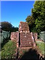
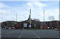
St. Catherine's Well, Coundon, Coventry
Restored late-medieval well, comprising a small, gabled structure resembling a chapel, standing on a rounded platform with a flight of steps, all built of sandstone. It stands in a fenced and locked enclosure amidst the between-the-wars suburbia of Beaumont Crescent and Paxton Road. It has been a Grade II listed building since 1955. https://historicengland.org.uk/listing/the-list/list-entry/1076662 Though the well is now dry, it once supplied the western side of Coventry with water. It is occasionally opened to the public. https://www.ourwarwickshire.org.uk/content/article/st-catherines-well-coundon-coventry
Image: © A J Paxton
Taken: 12 Jun 2021
0.03 miles
2
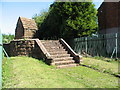
St Catherine's Well, Beaumont Crescent
Out in the countryside until the 20th century, this old conduit head was marked as 'Conduit Springs' on old OS maps. It is now sandwiched between 1920's suburban houses and surrounded by a metal fence. The sandstone building with the steeply pitched roof will have covered the spring head. Before the construction of Spon End waterworks in the mid 19th century the spring provided a water supply via pipe to public conduits in the Spon Street area, one location being Conduit Yard which was situated near St John's church.
A grade II listed building, no. 218417
Image: © E Gammie
Taken: 21 Jun 2010
0.05 miles
3
Holyhead Road, Coventry
The Holyhead Road was cut through from the city centre to Allesley as part of the improvements to the London-Holyhead coach route made by Thomas Telford in the 1820s. It was straighter and had a more even gradient than the previous section which went via Spon Street and the Allesley Road (now Allesley Old Road). The photographer's position would have been the centre of the road before the Alvis retail park necessitated changes to the road layout.
Image: © E Gammie
Taken: 21 Jun 2010
0.05 miles
4
Holyhead Road United Reformed Church
Image: © Keith Williams
Taken: 21 Apr 2008
0.07 miles
7
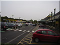
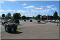
Morrison's Car park
Built on the former site of the Alvis car manufactures.
Two of Coventry's famous three spires can just be seen in the background.
Image: © Anthony Vosper
Taken: 7 Jun 2014
0.08 miles
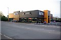
8
Morrison's on the Alvis Retail Park
The retail park is named after the Alvis factory that was previously on the site.
Image: © Keith Williams
Taken: 21 Apr 2008
0.09 miles
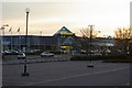
9
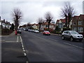
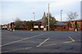
Moseley Avenue, Coundon
Traffic tails back due to road works at the junction with Holyhead Road.
Image: © Anthony Vosper
Taken: 17 Feb 2012
0.10 miles
10
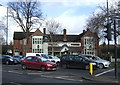
The Holyhead public house, Coventry
On Holyhead Road.
Image: © JThomas
Taken: 4 Mar 2017
0.12 miles