IMAGES TAKEN NEAR TO
Hewitt Avenue, COVENTRY, CV6 1NL
Introduction
This page details the photographs taken nearby to Hewitt Avenue, CV6 1NL by members of the Geograph project.
The Geograph project started in 2005 with the aim of publishing, organising and preserving representative images for every square kilometre of Great Britain, Ireland and the Isle of Man.

There are currently over 7.5m images from over14,400 individuals and you can help contribute to the project by visiting https://www.geograph.org.uk
Image Map
Images are licensed for reuse under creativecommons.org/licenses/by-sa/2.0
Notes
- Clicking on the map will re-center to the selected point.
- The higher the marker number, the further away the image location is from the centre of the postcode.
Image Listing (69 Images Found)
Images are licensed for reuse under creativecommons.org/licenses/by-sa/2.0
Image
Details
Distance
1
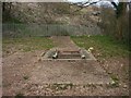
Radford brook culvert in Naul's Mill Park
The concrete shows the path of the culvert and the approximate path of the former brook. In the mid distance is a padlocked service hatch. The brook can be seen and heard through the grill. This is one of only two places where the brook can now be seen. In the heyday of the mill this area would probably have been under water.
Image: © starkderrick
Taken: 10 Apr 2013
0.08 miles
2
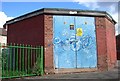
Bridgeman road sub station, located at the entrance to Naul's Mill Park
This building looks as though it is contemporary with the former council housing in the background.
Image: © starkderrick
Taken: 7 Oct 2011
0.09 miles
4
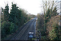
Railway towards Coventry Railway Station
Looking south west from the bridge on the Radford Road (B4098).
Image: © JThomas
Taken: 4 Mar 2017
0.12 miles
5
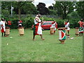
Burundian drummers, Nauls Mill Park
Burundian drummers performing at a Party in the Park, June 2010.
Image: © A J Paxton
Taken: 13 Jun 2010
0.13 miles
6
Coventry : Ashmore Road
Off Tomson Avenue.
Image: © Lewis Clarke
Taken: 25 Sep 2021
0.14 miles
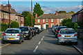
7
Coventry : Radford Circle
Approaching Radford Circle from Tomson Avenue.
Image: © Lewis Clarke
Taken: 25 Sep 2021
0.14 miles
8
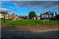
Coventry : Radford Circle
A grassy roundabout.
Image: © Lewis Clarke
Taken: 25 Sep 2021
0.14 miles
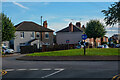
9
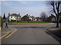
Radford Circle
Five roads converge on this enclosed green roundabout.
Image: © Anthony Vosper
Taken: 29 Mar 2014
0.14 miles
10
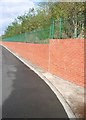
Embankment between Bridgeman Road and Radford Road
Between July 2005 and December 2005 the embankment between these two roads was stabilised and the retaining wall built. The trees and shrubs were planted as part of the works. Radford road was closed to vehicles for this period. The works cost £2.2m and were funded from central government. A streetlamp on Radford Road (which is higher than Bridgeman Road) can be seen against the sky. Bridgeman Road is the area of tarmac in the photo.
Image: © starkderrick
Taken: 7 Oct 2011
0.14 miles