IMAGES TAKEN NEAR TO
Hewitt Avenue, COVENTRY, CV6 1NJ
Introduction
This page details the photographs taken nearby to Hewitt Avenue, CV6 1NJ by members of the Geograph project.
The Geograph project started in 2005 with the aim of publishing, organising and preserving representative images for every square kilometre of Great Britain, Ireland and the Isle of Man.

There are currently over 7.5m images from over14,400 individuals and you can help contribute to the project by visiting https://www.geograph.org.uk
Image Map
Images are licensed for reuse under creativecommons.org/licenses/by-sa/2.0
Notes
- Clicking on the map will re-center to the selected point.
- The higher the marker number, the further away the image location is from the centre of the postcode.
Image Listing (68 Images Found)
Images are licensed for reuse under creativecommons.org/licenses/by-sa/2.0
Image
Details
Distance
1
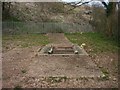
Radford brook culvert in Naul's Mill Park
The concrete shows the path of the culvert and the approximate path of the former brook. In the mid distance is a padlocked service hatch. The brook can be seen and heard through the grill. This is one of only two places where the brook can now be seen. In the heyday of the mill this area would probably have been under water.
Image: © starkderrick
Taken: 10 Apr 2013
0.09 miles
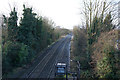
2
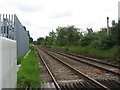
Coventry-Nuneaton line, northwards
A somewhat boring view towards Nuneaton from the Coundon Road level crossing. Very little visible to show that there were once platforms for Coundon Road station here. The station closed in 1965.
Image: © E Gammie
Taken: 9 Jun 2010
0.10 miles
3
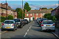
Coventry : Ashmore Road
Off Tomson Avenue.
Image: © Lewis Clarke
Taken: 25 Sep 2021
0.11 miles
4
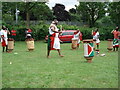
Burundian drummers, Nauls Mill Park
Burundian drummers performing at a Party in the Park, June 2010.
Image: © A J Paxton
Taken: 13 Jun 2010
0.11 miles
6
Coventry : Bablake School
Bablake School is a co-educational independent day school.
Image: © Lewis Clarke
Taken: 25 Sep 2021
0.13 miles
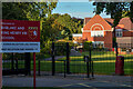
7
PDSA Pet Aid Hospital
A new build in Barker's Butts Road.
Image: © Anthony Vosper
Taken: 29 Mar 2014
0.14 miles
8
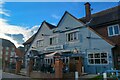
Coventry : The Coundon Hotel
This pub gets its name from the local Coventry suburb of Coundon. In 1929 the licence of the Rose in Well Street was removed to the Coundon. It is a large pub that stood opposite the Rugby Union Ground until it moved to the Butts Arena.
Image: © Lewis Clarke
Taken: 25 Sep 2021
0.14 miles
9
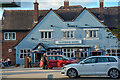
Coventry : The Coundon Hotel
This pub gets its name from the local Coventry suburb of Coundon. In 1929 the licence of the Rose in Well Street was removed to the Coundon. It is a large pub that stood opposite the Rugby Union Ground until it moved to the Butts Arena.
Image: © Lewis Clarke
Taken: 25 Sep 2021
0.14 miles
10
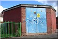
Bridgeman road sub station, located at the entrance to Naul's Mill Park
This building looks as though it is contemporary with the former council housing in the background.
Image: © starkderrick
Taken: 7 Oct 2011
0.14 miles