IMAGES TAKEN NEAR TO
Raphael Close, COVENTRY, CV5 8LS
Introduction
This page details the photographs taken nearby to Raphael Close, CV5 8LS by members of the Geograph project.
The Geograph project started in 2005 with the aim of publishing, organising and preserving representative images for every square kilometre of Great Britain, Ireland and the Isle of Man.

There are currently over 7.5m images from over14,400 individuals and you can help contribute to the project by visiting https://www.geograph.org.uk
Image Map
Images are licensed for reuse under creativecommons.org/licenses/by-sa/2.0
Notes
- Clicking on the map will re-center to the selected point.
- The higher the marker number, the further away the image location is from the centre of the postcode.
Image Listing (133 Images Found)
Images are licensed for reuse under creativecommons.org/licenses/by-sa/2.0
Image
Details
Distance
1
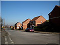
Wildcroft Rd Whoberley
A long residential street in one of the modernised Coventry housing estates. View north towards the junction with Brookside Avenue from close to the junction with Lyndale Road.
Image: © Nigel Mykura
Taken: 11 Feb 2012
0.05 miles
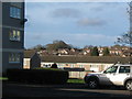
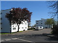
2
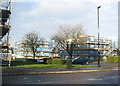
Flats off Lyndale Road
Undergoing external refurbishment.
Image: © E Gammie
Taken: 26 Jan 2014
0.06 miles
3
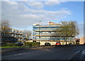
Lyndale Road
Flats off Lyndale Road undergoing external refurbishment.
Image: © E Gammie
Taken: 26 Jan 2014
0.06 miles
4
May blossom on Wildcroft Road
Cast not a clout 'til May be out. Well, it's out and it's definitely T-shirt weather (today, that is).
Image: © E Gammie
Taken: 22 May 2010
0.06 miles
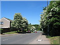
5
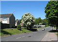
May, Wildcroft Road
A solo hawthorn in full blossom near the corner of Wildcroft Road and Brookside Avenue.
Image: © E Gammie
Taken: 22 May 2010
0.06 miles
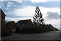
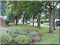
6
Lyndale Road
Looking beyond the flats and houses by Lyndale Road towards the trees near the top of Buckingham Rise.
Image: © E Gammie
Taken: 25 Dec 2013
0.07 miles
7
Wildcroft Road
Looking up Wildcroft Road at the junction with Lyndale Road. The houses on the corner were built on the site of the former Whoberley public house and its car park in the 1980s/90s. The eucalyptus tree on the corner is marginally younger than the houses. Further up Wildcroft Road are 1920s/30s bay fronted terraces.
Image: © E Gammie
Taken: 20 Mar 2012
0.08 miles
8
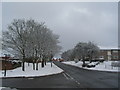
Wildcroft Road in the snow
Wildcroft Road and Brookside Avenue are clear of snow, having been gritted. The houses to the left are single storey houses built in the 1960s to replace pre-fabs. Those on the right were council houses when built c.1960s. The houses at the top were built c. 1990s on the site of the old Whoberley Hall school, which was rebuilt slightly north of its original site.
The trees to the right are hawthorns, possibly the remains of hedgerows.
Image: © E Gammie
Taken: 21 Jan 2013
0.08 miles
9
Lyndale Road
Flats in Lyndale Road and other houses in the locality have recently been refurbished with what appears to be external wall insulation.
Image: © E Gammie
Taken: 15 Apr 2014
0.08 miles
10
Wildcroft Road
Seen from the corner of Brookside Avenue.
Image: © E Gammie
Taken: 31 Aug 2015
0.09 miles