IMAGES TAKEN NEAR TO
Allesley Old Road, COVENTRY, CV5 8GB
Introduction
This page details the photographs taken nearby to Allesley Old Road, CV5 8GB by members of the Geograph project.
The Geograph project started in 2005 with the aim of publishing, organising and preserving representative images for every square kilometre of Great Britain, Ireland and the Isle of Man.

There are currently over 7.5m images from over14,400 individuals and you can help contribute to the project by visiting https://www.geograph.org.uk
Image Map
Images are licensed for reuse under creativecommons.org/licenses/by-sa/2.0
Notes
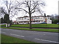
- Clicking on the map will re-center to the selected point.
- The higher the marker number, the further away the image location is from the centre of the postcode.
Image Listing (51 Images Found)
Images are licensed for reuse under creativecommons.org/licenses/by-sa/2.0
Image
Details
Distance
1
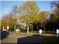
London Plane, Holyhead Road
Taken from the Toll Gate car park this fine example is at least 70 years old.
These trees can resist atmospheric pollution and are one of the most common trees planted in towns and cities.
Image: © Anthony Vosper
Taken: 28 Oct 2009
0.05 miles
2
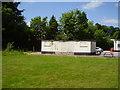
Bowled out at the Toll gate public house
In the 1960's many of the public houses in the area had bowling greens.
All that remains now is the boarded up club house.
Image: © Anthony Vosper
Taken: 7 Jun 2015
0.05 miles
3
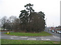
Central reservation, Allesley Old Road
1913-25 old Ordnance Survey 1:2500 maps show Allesley Old Road as a single carriageway road running to the right of the trees. By the time of the 1936-7 1:2500 maps the road is shown as a dual carriageway with a new carriageway having been created to the left of the trees.
Image: © E Gammie
Taken: 9 Feb 2012
0.06 miles
4
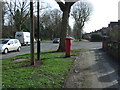
Path beside Holyhead Road, Coventry
Showing position of postbox No. CV5 288.
See Image] for postbox.
Image: © JThomas
Taken: 4 Mar 2017
0.07 miles
5
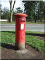
George VI postbox on Holyhead Road, Coventry
Postbox No. CV5 288.
See Image] for context.
Image: © JThomas
Taken: 4 Mar 2017
0.07 miles
6
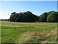
Pitch and putt, Allesley Park
Part of the public pitch and putt course at Allesley Park. A small pond is hidden amongst the trees and ridge and furrow markings are faintly visible in front of the trees to the right.
A wider view in October 2006: Image]
Image: © E Gammie
Taken: 7 Aug 2016
0.07 miles
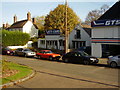
7
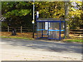
Waiting for the bus
The Toll Gate and Dulverton Avenue stop for the local bus service.
Image: © Anthony Vosper
Taken: 28 Oct 2009
0.08 miles
8
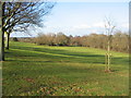
Allesley Park
Part of the public pitch and putt golf course at Allesley Park. The water hazard is in the circle of trees.
In October 2006: http://www.geograph.org.uk/photo/269790
Image: © E Gammie
Taken: 30 Jan 2012
0.08 miles
9
The Toll Gate
The 1930's Art Deco style public house on Holyhead Road is situated a few yards from the original location of the toll house and gate on the London to Holyhead turnpike. There was also a wooden tithe barn near here.
Update: A 1930's car park light, shown to good effect in Image, is visible on the pole to the right of the advertising sign. Sadly, it was no longer atop the pole when I went past on 9 Feb 2012.
Image: © E Gammie
Taken: 25 Dec 2008
0.08 miles
10
Allesley Old Road, Garage
This road once was a busy thoroughfare. The road is now a dead end and the garage by passed.
A classic M.G on view as well.
Image: © Anthony Vosper
Taken: 28 Oct 2009
0.08 miles