IMAGES TAKEN NEAR TO
Gorseway, COVENTRY, CV5 8BJ
Introduction
This page details the photographs taken nearby to Gorseway, CV5 8BJ by members of the Geograph project.
The Geograph project started in 2005 with the aim of publishing, organising and preserving representative images for every square kilometre of Great Britain, Ireland and the Isle of Man.

There are currently over 7.5m images from over14,400 individuals and you can help contribute to the project by visiting https://www.geograph.org.uk
Image Map
Images are licensed for reuse under creativecommons.org/licenses/by-sa/2.0
Notes
- Clicking on the map will re-center to the selected point.
- The higher the marker number, the further away the image location is from the centre of the postcode.
Image Listing (73 Images Found)
Images are licensed for reuse under creativecommons.org/licenses/by-sa/2.0
Image
Details
Distance
1
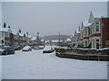
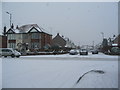
Gorseway at Heathfield Road
Looking east along Gorseway from the junction with Heathfield Road. It had been snowing steadily all morning and reached about 10cm by this time.
The housing here is short bay-windowed terraces dating from the 1930s, typical of many of Coventry's suburbs. The trees beyond the houses are on Hearsall Common.
Image: © E Gammie
Taken: 18 Jan 2013
0.05 miles
2
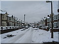
Heathfield Road in the snow
Snowfalls on the 18th and 20th gave a 15cm covering for several days. Heathfield Road, being a side road, has not been gritted so snow has been compacted to ice by the passage of traffic.
The road consists of short terraces of 1930s bay-windowed houses with a few semis all in a style common to several of Coventry's suburbs.
Image: © E Gammie
Taken: 21 Jan 2013
0.07 miles
4
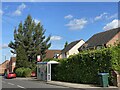
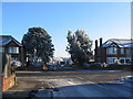
Wildcroft Road
Looking up Wildcroft Road at the junction with Lyndale Road. The houses on the corner were built on the site of the former Whoberley public house and its car park in the 1980s/90s. The eucalyptus tree on the corner is marginally younger than the houses. Further up Wildcroft Road are 1920s/30s bay fronted terraces.
Image: © E Gammie
Taken: 20 Mar 2012
0.09 miles
5
Gorseway at Wildcroft Road
The snow had been falling steadily and reached approx 4"(10cm) by this time. The car on the left is gingerly negotiating Wildcroft Road which, as a bus route, would be gritted at some point.
The houses are 1930s bay-windowed semis and short terraces, typical of several of Coventry's suburbs.
Image: © E Gammie
Taken: 18 Jan 2013
0.09 miles
6
Gorseway, Whoberley
Gorseway is oriented East-West and in winter is shaded much of the day, so ice and snow are slow to clear. A large monkey puzzle tree dominates the corner with Wildcroft Road. The frost covered trees in the distance are on Hearsall Common (SP3078).
1920s/30s bay-fronted brick houses in short terrace groups.
Image: © E Gammie
Taken: 7 Dec 2010
0.10 miles
7
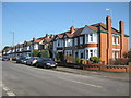
Houses on Wildcroft Rd
These substantial red brick semi detached houses probably dating from the 20's or 30's are on the east side of the road between the junctions with Gorseway and Heathfield Rd
Image: © Nigel Mykura
Taken: 11 Feb 2012
0.10 miles
8
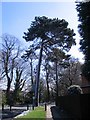
Scots pine, Guphill Ave
The overnight snow has melted in the sunlight but remains on the north side of the pine and in the shadows.
Image: © E Gammie
Taken: 6 Apr 2008
0.10 miles
9
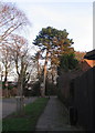
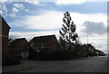
Guphill Avenue
Looking towards Hearsall Common woodland. The Scots pine on the corner is one of several dotted along Guphill Avenue. On old OS maps Guphill Avenue is shown as Whoberley Lane and was the main approach to Whoberley Hall. The road has been closed to motor traffic other than for access to prevent it being used as a rat-run to avoid the Glendower Avenue / Broad Lane traffic light hold up.
Image: © E Gammie
Taken: 27 Jan 2008
0.12 miles
10
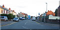
Whoberley Avenue
A Sunday afternoon and, unusually, a double decker bus is making its way into town in contrast to weekday commuting times when it's a closely packed single-decker.
Image: © E Gammie
Taken: 7 Nov 2010
0.12 miles