IMAGES TAKEN NEAR TO
Inverness Close, COVENTRY, CV5 7NA
Introduction
This page details the photographs taken nearby to Inverness Close, CV5 7NA by members of the Geograph project.
The Geograph project started in 2005 with the aim of publishing, organising and preserving representative images for every square kilometre of Great Britain, Ireland and the Isle of Man.

There are currently over 7.5m images from over14,400 individuals and you can help contribute to the project by visiting https://www.geograph.org.uk
Image Map
Images are licensed for reuse under creativecommons.org/licenses/by-sa/2.0
Notes
- Clicking on the map will re-center to the selected point.
- The higher the marker number, the further away the image location is from the centre of the postcode.
Image Listing (13 Images Found)
Images are licensed for reuse under creativecommons.org/licenses/by-sa/2.0
Image
Details
Distance
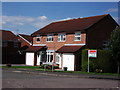
1
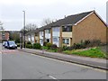
Alderminster Road
This short row of modern terraced housing is opposite Perth Rise and close to the junction with Unicorn Road.
Image: © Nigel Mykura
Taken: 6 Mar 2011
0.11 miles
3
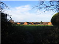
Allesley Green from Park Hill Lane
A 1980s housing estate. Just visible on the skyline is the woodland north of Meriden.
Image: © E Gammie
Taken: 1 Dec 2007
0.16 miles
4
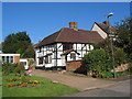
Lower Eastern Green Farmhouse
A 16th century timber framed former farmhouse in Unicorn Lane, now surrounded by 20th century housing.
A grade II listed building. LBS no. 218591
Image: © E Gammie
Taken: 10 Oct 2010
0.17 miles
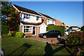
5
Houses at the junction of Beaumaris Close and Parkhill Drive
I believe this part of the estate was built in the 1980's by Bryant Homes.
Image: © John Brightley
Taken: 31 Aug 2010
0.20 miles
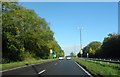
6
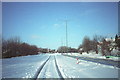
Single track carriageway, Dunchurch Highway
Sunday 9th December 1990, the morning after a major snowfall paralysed the roads in the area. The Dunchurch Highway (A45) between Broad Lane and Pickford Way was closed overnight, the undulating profile having caused the undoing of several vehicles. Normally two lane carriageways, the few vehicles that passed this way followed a single track here at the top of the rise near Allesley Park.
Image: © E Gammie
Taken: 9 Dec 1990
0.20 miles
9
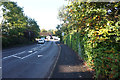
Parkhill Drive towards Lower Eastern Green Lane
Image: © Ian S
Taken: 29 Aug 2019
0.22 miles
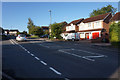
10
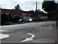
The junction of Parkhill Drive and Lower Eastern Green Lane
This shows the mini roundabout junction but also the poor state of the road surface - all Coventry's roads have been poorly maintained for many years and they are only now being improved.
Image: © John Brightley
Taken: 31 Aug 2010
0.24 miles