IMAGES TAKEN NEAR TO
Centaur Road, COVENTRY, CV5 6LG
Introduction
This page details the photographs taken nearby to Centaur Road, CV5 6LG by members of the Geograph project.
The Geograph project started in 2005 with the aim of publishing, organising and preserving representative images for every square kilometre of Great Britain, Ireland and the Isle of Man.

There are currently over 7.5m images from over14,400 individuals and you can help contribute to the project by visiting https://www.geograph.org.uk
Image Map
Images are licensed for reuse under creativecommons.org/licenses/by-sa/2.0
Notes
- Clicking on the map will re-center to the selected point.
- The higher the marker number, the further away the image location is from the centre of the postcode.
Image Listing (150 Images Found)
Images are licensed for reuse under creativecommons.org/licenses/by-sa/2.0
Image
Details
Distance
1
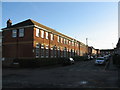
Centaur Road
School buildings on Centaur Road with Kingston Road crossing in the foreground. An area of red-brick terraces dating from the early 20th century.
Image: © E Gammie
Taken: 12 Jan 2012
0.01 miles
2
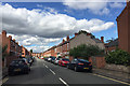
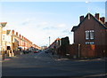
Centaur Road, Earlsdon, Coventry
It is crossed by Bristol Road and Kingston Road before it meets Sovereign Road. Behind the camera is Broomfield Road. These are all residential streets of terraced houses.
Image: © Robin Stott
Taken: 8 Sep 2016
0.02 miles
3
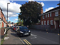
East on Kingston Road, Earlsdon, Coventry
The side entrance to the school has 'Infants' over the door. Behind the camera is Centaur Road.
Image: © Robin Stott
Taken: 8 Sep 2016
0.05 miles
4
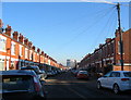
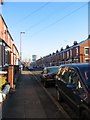
Kingston Road, Earlsdon
Early 20th century red brick terraces. Flat ground floor frontages in contrast to nearby Sovereign Road ( http://www.geograph.org.uk/photo/2189951 ). The tower block in the distance is the Ramada hotel in the Butts (SP3278).
Image: © E Gammie
Taken: 7 Dec 2010
0.05 miles
5
Broomfield Road
Houses in Broomfield Road date from around 1906 with the exception of the apartments on the corner to the left which are late 20th century.
Image: © E Gammie
Taken: 12 Jan 2012
0.05 miles
6
Sovereign Road, Earlsdon
Early 20th century red brick terraces. Ground floor window bays in contrast to flat frontages in nearby Kingston Road ( http://www.geograph.org.uk/photo/2189942 ). The tower block in the distance is the Ramada hotel in the Butts (SP3278).
Image: © E Gammie
Taken: 7 Dec 2010
0.07 miles
7
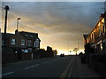
Top of Broomfield Road
Into the sunset, look out for those traffic lights. The house on the left corner has a 'front' facing both Earlsdon Avenue North and Broomfield Road.
Image: © E Gammie
Taken: 23 Jan 2012
0.09 miles
8
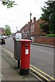
Georgian postbox at the end of Bristol Road
Image: © Keith Williams
Taken: 5 May 2008
0.10 miles
9
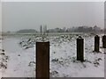
Powdery snow on Hearsall Common
A cold late afternoon in early March, looking across the common from Earlsdon Avenue North towards Chapelfields and Whoberley.
Image: © A J Paxton
Taken: 2 Mar 2018
0.10 miles
10
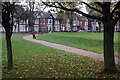
Hearsall Common
Although Hearsall Common can trace its origins as common land back to the 13th century, it was reassigned as recreation ground in 1927. It is now a significant open space to the west of Coventry city centre. This view shows one corner of the common looking towards Earlsdon Avenue.
Image: © Stephen McKay
Taken: 5 Nov 2021
0.10 miles