IMAGES TAKEN NEAR TO
Shakleton Road, COVENTRY, CV5 6HU
Introduction
This page details the photographs taken nearby to Shakleton Road, CV5 6HU by members of the Geograph project.
The Geograph project started in 2005 with the aim of publishing, organising and preserving representative images for every square kilometre of Great Britain, Ireland and the Isle of Man.

There are currently over 7.5m images from over14,400 individuals and you can help contribute to the project by visiting https://www.geograph.org.uk
Image Map
Images are licensed for reuse under creativecommons.org/licenses/by-sa/2.0
Notes
- Clicking on the map will re-center to the selected point.
- The higher the marker number, the further away the image location is from the centre of the postcode.
Image Listing (301 Images Found)
Images are licensed for reuse under creativecommons.org/licenses/by-sa/2.0
Image
Details
Distance
1
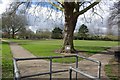
Broomfield Park
The plaque at the base of the tree describes the dedication of the park and is shown Image
Image: © Keith Williams
Taken: 28 Mar 2009
0.04 miles
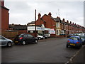
2
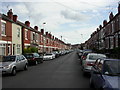
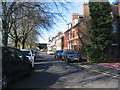
Coventry, Melbourne Road
Victorian redbrick terraces.
Image: © Mike Faherty
Taken: 3 Jul 2010
0.05 miles
3
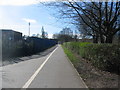
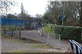
Footpath and cycleway
The path runs between Butts Park rugby ground on the left and Broomfield Park on the right to pass under the Coventry-Nuneaton rail line to Sovereign Road ( Image] ).
Image: © E Gammie
Taken: 9 Mar 2017
0.05 miles
4
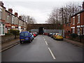
Sovereign Road, Spon End
Late Victorian houses in the heart of the city.
Spon End was once the centre of the city's watch making industry.
Image: © Anthony Vosper
Taken: 14 Feb 2015
0.05 miles
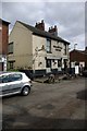
6
Noble Motors, Shackleton Road
A small back street family-owned garage and car sales establishment.
Image: © Anthony Vosper
Taken: 14 Feb 2015
0.06 miles
7
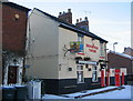
Broomfield Tavern, closed
Notices on the windows say that the pub is 'temporarily closed' and a 'To Let' sign takes the place of the inn sign. The Tavern is known to have traded since 1868.
Update: Re-opened in 2011.
Image: © E Gammie
Taken: 19 Dec 2010
0.07 miles
9
Broomfield Place
At the end of the cul de sac is the first (or last) of the arches of the railway viaduct crossing the Sherbourne valley which gives pedestrian access to the other end of Broomfield Place.
Image: © E Gammie
Taken: 9 Mar 2017
0.07 miles
10
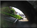
Broomfield Place
Broomfield Place is split by the Coventry-Nuneaton railway line. The two halves are connected by this footpath under one of the lower arches of the Spon End viaduct ( Image] ).
Image: © E Gammie
Taken: 12 May 2016
0.07 miles