1
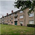
Block of flats on Gregory Hood Road, the Stonebridge Estate
These council flats were built in 1950-51 by Wimpey, using the 'no fines' method (concrete without fine, sandy aggregates, a cheaper method of building) for the Coventry City Architect's Department under Donald Gibson. See
Image] for further information.
Image: © A J Paxton
Taken: 29 Aug 2023
0.10 miles
2
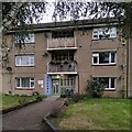
Mass-produced housing: Blocks of flats, Fred Lee Grove
These three-storey blocks on the Stonebridge estate on the southern edge of Coventry were built in 1950-51 by Wimpey to the designs of the City Architect's Department under Donald Gibson. See
Image] for more information. In the words of Jeremy & Caroline Gould, "The monotony... was disappointing and the experiment proved that, since the houses were architecturally modest, it would require imaginative layout, varied density and a richer landscape to make distinctive places." See their e-book, 'Coventry, the making of a modern city 1939-73', p84, at the Historic England site https://historicengland.org.uk/images-books/publications/coventry-making-of-modern-city-1939-73/ . How many volume housebuilders today would even attempt to make 'distinctive places'?
Image: © A J Paxton
Taken: 29 Aug 2023
0.12 miles
3
Entrance to flats on Gregory Hood Road, Coventry
This is a close up of an entrance to the flats depicted at
Image The glazed tiles with flat numbers and a pastel-shaded surround (a different colour for each entrance) are details that show care and concern for tenants and their environment. These flats date from 1950-51; later on, pressure on the council to build fast and cheap would lead to the shoddiness seen, for example, at
Image
Image: © A J Paxton
Taken: 29 Aug 2023
0.13 miles
4
Whitley Common, Stivichall, Coventry, early summer
A gap in the trees reveals the A444, a road to and from the city centre. The blobby brown grass in the foreground is Cocksfoot. Colour in the distance is from buttercups and a sorrel species. I may be wrong to call this land – between Leaf Lane and the dual carriageway – Whitley Common; there is no name on the map.
Image: © Robin Stott
Taken: 8 Jun 2016
0.17 miles
5
The A444 heading to Coventry
Image: © Steve Daniels
Taken: 23 Mar 2019
0.19 miles
6
View of the A46
Image: © Dave Thompson
Taken: 6 Jan 2021
0.22 miles
7
Leaf Lane, Stivichall, Coventry
Gas mains were being replaced, hence digger-wagon and traffic management on a busy suburban road.
Image: © Robin Stott
Taken: 17 Feb 2015
0.22 miles
8
Chatsworth Rise, Stivichall, Coventry
Seen from Okehampton Road.
Image: © Robin Stott
Taken: 17 Feb 2015
0.22 miles
9
Okehampton Road, Stivichall, Coventry
One of several residential roads with Devonshire and West Country names.
Image: © Robin Stott
Taken: 17 Feb 2015
0.23 miles
10
The A444 under the Stivichall Roundabout
There is a nice open bit of road I am trying to get to, but I am stuck in traffic on the roundabout. The road becomes the A46 south of the roundabout.
Image: © Bill Boaden
Taken: 26 Jun 2015
0.23 miles


