IMAGES TAKEN NEAR TO
Lodge Crescent, WARWICK, CV34 6BB
Introduction
This page details the photographs taken nearby to Lodge Crescent, CV34 6BB by members of the Geograph project.
The Geograph project started in 2005 with the aim of publishing, organising and preserving representative images for every square kilometre of Great Britain, Ireland and the Isle of Man.

There are currently over 7.5m images from over14,400 individuals and you can help contribute to the project by visiting https://www.geograph.org.uk
Image Map
Images are licensed for reuse under creativecommons.org/licenses/by-sa/2.0
Notes
- Clicking on the map will re-center to the selected point.
- The higher the marker number, the further away the image location is from the centre of the postcode.
Image Listing (52 Images Found)
Images are licensed for reuse under creativecommons.org/licenses/by-sa/2.0
Image
Details
Distance
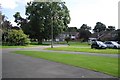
1
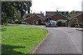
Leyfields Crescent, Warwick
One of several residential streets that look out to the boundary of Warwick Castle Park.
Image: © Robin Stott
Taken: 28 Aug 2009
0.05 miles
2
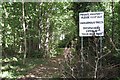
Access to woodland, Leyfields Crescent, Warwick
Well-worn paths form a circuit round and criss-cross a belt of degraded woodland on the western boundary of Warwick Castle Park. It appears to be part of Leafield Farm, hence the feeble attempts to prevent informal access. Other residential streets to the north are graced with heavy security fencing to prevent access to the pay-to-enter Castle grounds.
Image: © Robin Stott
Taken: 28 Aug 2009
0.05 miles
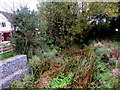
3
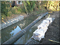
Fisher's Brook flood alleviation works southwest of Lodge Crescent
Compare with Image The height of the right-hand bank has been reduced.
Image: © Robin Stott
Taken: 1 Dec 2012
0.09 miles
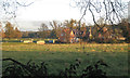
4
Fisher's Brook, Warwick
Viewed from Stratford Road on Fisher's Bridge. In early October 2015, no surface water is visible on this tiny tributary of the River Avon.
Image: © Jaggery
Taken: 3 Oct 2015
0.11 miles
5
Flood alleviation work in progress below Fisher's Bridge
The brook in a pipe is carried clear while other works are implemented at the side of a property in Stratford Road.
Image: © Robin Stott
Taken: 1 Dec 2012
0.11 miles
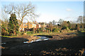
6
The end of Lodge Crescent, off Foxes Way, Warwick
The most spacious of the residential developments sandwiched between West Street/Stratford Road and Warwick Castle grounds.
Image: © Robin Stott
Taken: 27 Aug 2009
0.11 miles
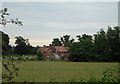
8
Houses near Leafield Farm
Leafield Farm, out of shot right, is a tenancy within Warwick Castle Park. These houses are halfway down the track to the farm. On the left is the little bridge that carries the track over Fisher's Brook. In the background is Lodge Wood on the south side of the river Avon. Seen through hedge along Stratford Road.
Image: © Robin Stott
Taken: 1 Dec 2012
0.12 miles
9
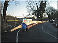
Fisher's Bridge, traffic barrier and temporary parapet
Single-file traffic operated over the bridge while contractors constructed a new culvert to alleviate flooding. Two wider views are Image and Image
Image: © Robin Stott
Taken: 1 Dec 2012
0.12 miles
10
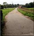
Leafield Farm access road, Warwick
From Stratford Road in the south of Warwick.
Image: © Jaggery
Taken: 3 Oct 2015
0.12 miles